Advanced Information Systems Technology
Pioneering the Next-Generation of Intelligent Systems for Earth Science
Program Manager – Laura Rogers
Advanced Modeling Technology (AMT) Program
NASA’s Advanced Information Systems Technology (AIST) Program identifies, develops, and supports adoption of software and information systems, as well as novel computer science technologies expected to be needed by the Earth Science Division in the 5-10-year timeframe.
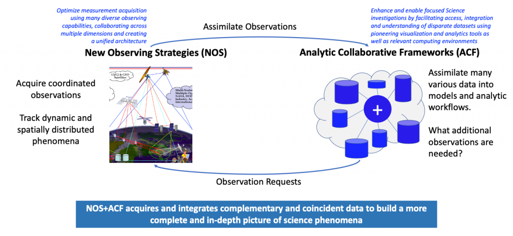
AIST’s thrusts have been New Observing Strategies (NOS) and Analytic Collaborative Frameworks (ACF). A third thrust — Earth System Digital Twins (ESDT) — is being pursued under the newest ESTO program: Advanced Modeling Technology (AMT).
NOS Technologies
NOS Technologies, which respond to Objective O1, concentrate on optimizing measurement acquisitions by using diverse observing and modeling capabilities, representing various resolutions, dynamically coordinated and collaborating to provide complete representations of Earth Science phenomena. The observing assets can be in space, in the air, or in situ, and the observed phenomena may exist on a variety of spatial or temporal scales (e.g., real-time tracking of hazards and disasters or long-term asset coordination for continuous ecosystem monitoring). NOS can be described as a federated Observing System, a generalized SensorWeb, or more generally as an “Internet-of-Space (IoS)” concept in which each node can be a sensor, a group of sensors, a constellation of satellites (e.g., Earth System Observatory concept), a model or integrated models, or even database(s) or any other source of relevant information, that have varying degrees of coordination to achieve a common science objective. The two main NOS goals are to:
- Design and develop future observation concepts at the request of a new measurement, for example as identified in the latest Decadal Survey or as the result of a model or other science data analysis; and
- Dynamically respond to science and applied science events of interest, not only focusing on rapid disaster-like events, but also considering mid- and long-term events and various area coverages, from global to regional to local-impact events, (e.g., distressed vegetation, potential landslides due to runoff, etc.).
More details about NOS are available in the 2020 NOS Workshop Report. A prototyped use case using a flood scenario and the NOS Testbed is presented in the first NOS-Testbed (NOS-T) demonstration (May 28, 2021).
For more information on AIST NOS projects, please download our 2021 NOS Annual Reviews (PDF / 184MB).
ACF Technologies
Once an Earth observing mission is in operation, we can expect a lot of data back on land. Data from different missions often arrive in different formats, and when combined with ground-based and airborne-derived data, things get tricky. Scientists can look to this framework, which incorporates software tools like machine learning, to help them more easily use and visualize the data in their research.
ACF technologies respond to AIST Objective O2 and address the challenges associated to observing systems such as NOS systems which will acquire an increased variety and volume of data over various geographical scales, latencies, and frequencies. The ACF thrust is designed to facilitate access, integration, and understanding of large amounts of disparate datasets. Its purpose is to harmonize analytics tools, data, visualization and computing environments to meet the needs of Earth science investigations and applications. The ACF thrust integrates new or previously unlinked datasets, tools, models, and a variety of computing resources together into a common platform to address previously intractable scientific and science-informed application questions. Additionally, this activity seeks to generalize custom or unique tools that are currently used by a limited community of experts or practitioners, to make them accessible and useful to a broader community. ACF focuses on reducing the amount of time a science user spends on data preparation and enables the tailoring of configurations of datasets and reusable tools to avoid repetitive work (e.g., by developing reusable components).
Both NOS and ACF aim at optimizing Earth Science mission return – NOS from an observation point of view and ACF from an analysis point of view. The assets and data accessed and utilized in these investigations may come from NASA and non-NASA sources, as described in the National Academy of Sciences (NAS) 2017 Earth Science Decadal Survey.
For more information on AIST ACF projects, please download our 2021 ACF Project Reviews from January (PDF / 111MB) and February (PDF / 116MB). For more information about how autonomy can impact future NASA missions, please explore the 2018 Workshop on Autonomy for Future NASA Science Missions.
Events & Reports
AIST and AMT host workshops, conferences, and project reviews to educate the science community about breakthroughs in the world of information systems.
Events and ReportsAIST and AMT Project Highlights
Novel Algorithms Merge Ground- and Space-based Data to Forecast Air Pollution Events
A NASA-sponsored research team is developing new machine-learning software that uses data from satellites and ground-based sensors to forecast air pollution events in Los Angeles.
Novel software testbed helps prepare sensors for future cooperative networks
A collaborative team of researchers from numerous organizations demonstrated a novel software platform that will help networks of dispersed sensors share information with each other more efficiently.
NASA Agricultural Digital Twin will help farmers improve crop yield forecasts
A team of researchers supported by ESTO is developing an agriculture information system that will provide farmers with better agricultural productivity forecasts.
Solicitations
AIST uses the NASA Research Announcement as its investment vehicle. Links to the full solicitations and awards are listed below.
—
AIST Solicitations
| Solicitation | Link To Solicitation | Link To Award |
|---|---|---|
| AIST ROSES 2023 (includes AMT assignments) | Solicitation Closed | Updates Pending |
| AIST ROSES 2021 | Solicitation (link) | Awarded Projects |
| AIST ROSES 2018 | Solicitation (link) | Awarded Projects |
| AIST ROSES 2016 | Solicitation (link) + Preproposal Virtual Bidders' Conference | Awarded Projects |
| AIST ROSES 2014 | Solicitation (link) | Awarded Projects |
| AIST ROSES 2011 | Solicitation (135 K PDF) | Awarded Projects |
| AIST ROSES 2008 | Solicitation (112 K PDF) | Awarded Projects |
| AIST ROSES 2005 | Solicitation (432 K PDF) | Awarded Projects |
| AIST Master NRA 2004 | Solicitation (177 K PDF) Mini-Solicitation NNG04ZY4001N (51 K PDF) | [not applicable] Awarded Projects |
| AIST NRA 2002 | Solicitation (998 K PDF) | Awarded Projects |
| AIST NRA 1999 | Solicitation (227 K PDF) | Awarded Projects |