Novel software testbed helps prepare sensors for future cooperative networks
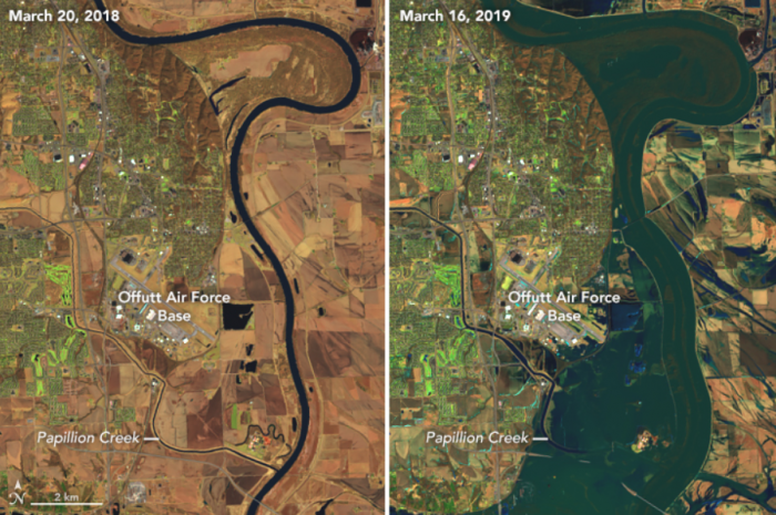
Above: Record flooding in 2019 caused more than $1 billion of damage in the Midwest. Future New Observing Strategies (NOS) could help improve flood forecasting and provide communities with more time to prepare. Image Credit: NASA / Landsat 8
12/13/22 – Innumerable sensors around and beyond our world supply scientists with the data they need to study intricate Earth phenomena. But each individual sensor can only observe so much, making it difficult for researchers to fully understand these massive, complicated Earth systems.
“Working together, communities of remote sensors help us create a full picture of Earth events. But uniting sensors from different entities together into one system isn’t always easy,” said Paul Grogan, researcher with the Systems Engineering Research Center and Director of the Collective Design (CoDe) Lab at the Stevens Institute of Technology.
With support from ESTO, a collaborative team of researchers from numerous organizations – including JPL, GSFC, ARC, LaRC, the University of Maryland, and USGS – recently demonstrated a novel software platform that will help networks of dispersed sensors share information with each other more efficiently. The platform, New Observing Strategies Testbed (NOS-T), merged data from ground-based, spaceborne, and airborne sensors scattered across the country into a single data product that describes the 2019 Midwest Floods, which caused more than $1 billion worth of damage.
“We had a very successful demonstration. NOS-T helped us see how a diverse variety of events contributed to these severe floods in the Midwest – including increased levels of river ice, unusually deep layers of soil frost, and heavy precipitation. It’s hard to see that complete picture using just a single set of sensor nodes,” said Jerry Sellers, a researcher at the Stevens Institute of Technology who worked with Grogan to design the NOS-T platform.
16 researchers and data professionals from a dozen different institutions worked together during the NOS-T demonstration, generating an event-driven software architecture to leverage USGS river gauges, NASA weather satellites, university soil-moisture sensors, and other instruments together into a collaborative sensing architecture, which provided researchers with a far more comprehensive view of the 2019 floods than any single sensor ever could.
“We have all these sensors installed for individual purposes, but the data they gather could actually be combined to accomplish more scientific objectives. We just have to implement a communications fabric that enables these sensors to share their data with one another more easily,” said Grogan.
NOS-T is a critical next step in NASA’s New Observing Strategies (NOS) initiative, an ESTO-led push to develop new information technologies that will allow researchers to operate dynamic, multi-element sets of observing assets.
“Existing sets of Earth-monitoring sensors could be used to gather new or improved observations of Earth’s complex systems. Building information systems that enable these connections could help scientists accomplish their research objectives without starting from scratch and developing completely new instruments,” said Jacqueline Le-Moigne, ESTO’s Advanced Information Systems Technology (AIST) program manager.
Sujay Kumar, a Research Physical Scientist at NASA’s Goddard Space Flight Center (GSFC) who helped manage the modeling and science scenario components of the demonstration, expects NOS to become a critical component of future Earth system observations.
“NOS-T was really the first proof-of-concept for our NOS initiative. With this successful demonstration, we’re one step closer to connecting existing sensor nodes with our Earth system modeling capabilities that could greatly improve our ability to study our world,” he said.
Ben Smith, an ESTO Associate at NASA’s Jet Propulsion Laboratory (JPL) who coordinated the NOS-T flood-case demonstration, adds that NOS technologies will become critical for quickly developing in-depth data products describing things like severe weather events and climate change.
“The ability to coordinate intelligently among in-situ sensors, forecast models, and satellites could produce a more comprehensive picture of events, like floods, as they are happening”, he said.
Bringing together disparate sensor networks operating in different domains and managed by different organizations, even different countries, is no easy task. They may not have the same hardware, use the same interface protocols, or even speak the same programming language.
“It’s kind of like being in an online meeting where everyone is trying to talk at once. At the end of the day, very little information has been shared. And if folks in the meeting are all speaking different languages, it’s even harder to communicate,” said Grogan.
But a testbed platform like NOS-T gives researchers an opportunity to socialize different sensors using real-world data. NOS-T can simulate Earth science scenarios, allowing researchers to prototype different techniques for connecting different sensors before bringing those techniques to the field. A cloud-based software, NOS-T is accessible simultaneously to researchers as geographically dispersed as their sensor nodes.
“We had people working together in real-time from California, Washington, Maryland, and Michigan. The opportunities for collaboration are endless,” said Sellers.
Researchers will continue to prototype novel observation strategies with NOS-T as they work to integrate these strategies into the real world. As these strategies continue to evolve, the NOS architecture will continue to evolve, establishing a framework for future collaborative sensing that dramatically improve our ability to observe planet Earth.
“We’ve shown that the NOS-T technology concept is feasible. Now we just need to continue developing these concepts to incorporate more diverse groups of sensor networks, including industry, government partners and academia,” said Grogan.
Gage Taylor, NASA Earth Science Technology Office