Earth Science Technology Interchange Meeting
Welcome
The 2026 Earth Science Technology Interchange Meeting (ESTIM2026) was held September 22-24 in Chicago, IL. Building upon ESTO events from prior years, particularly the annual Earth Science Technology Forum series, ESTIM2026 was an in-person meeting intended to promote collaboration and networking among technologists, scientists, and mission planners. ESTIM2026 showcased over 60 technical talks on the wide array of technology research and development underway for Earth science, including remote sensing instruments, platforms, components, advanced information systems, and modeling.
This meeting was convened by invitation only.
—
Schedule at a Glance
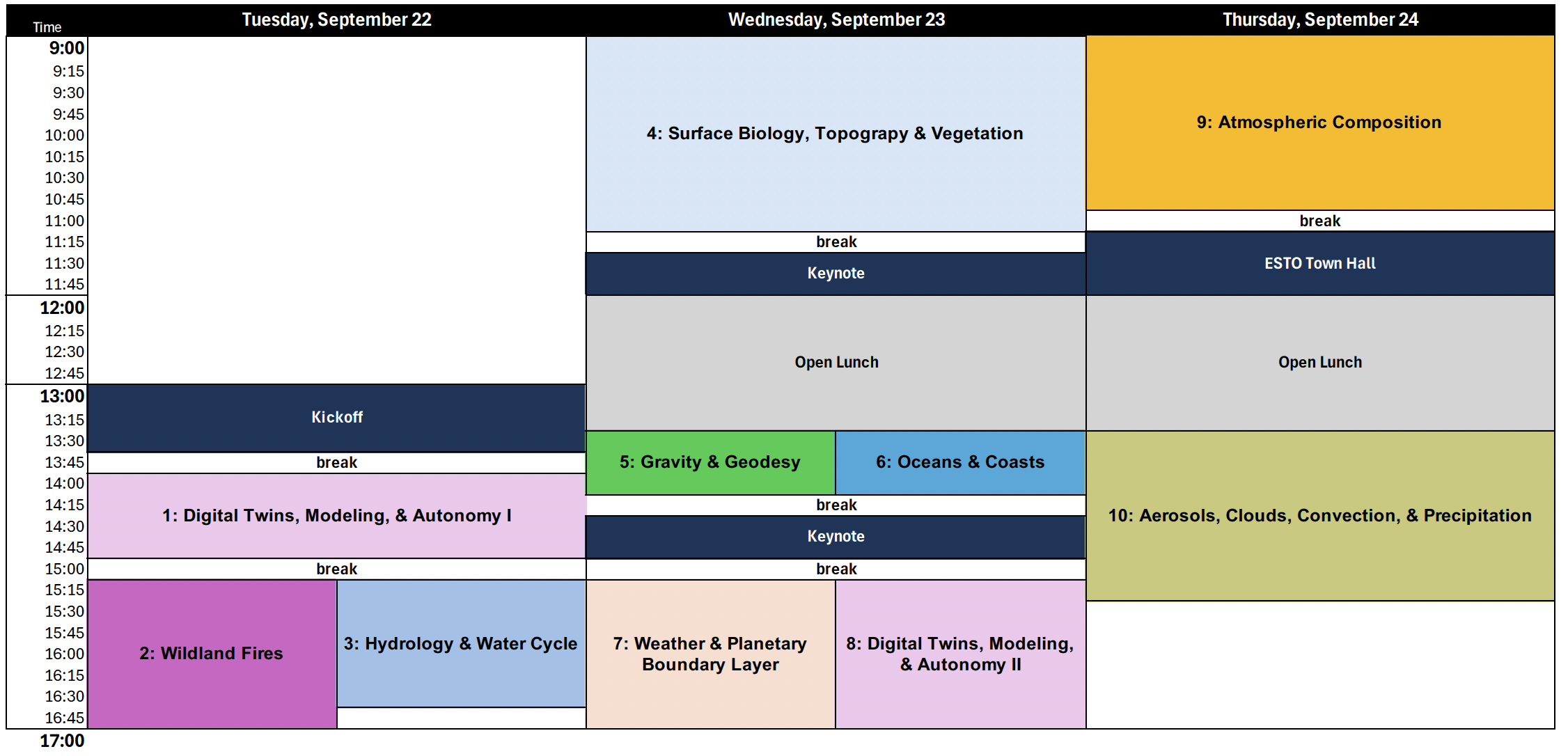
—
Full Proceedings
Tuesday, September 22 — Day One
13:00 Welcome and Opening Remarks
– Karen St. Germain, Director, NASA Earth Science Division
– Michael Seablom, Associate Director for Technology, NASA Earth Science Division
13:45 Break
Session 1: Digital Twins, Modeling, & Autonomy I
Session Moderator: Laura Rogers
14:00 Umaa Rebbapragada: Using a Digital Twin and New Observing Systems for Urban Heat Decision Support and Mitigation
14:15 Lukas Mandrake: PILLAR: Enabling LLM’s to correctly use NASA data from today forward
14:30 Jennifer Sleeman: AI for Earth System Prediction, Scientific Discovery, and Climate Tipping-Point Analysis
14:45 Alberto Candela: Dynamic Targeting: Improving Spacecraft Mission Science Return Through Real-Time Onboard Decision-Making
15:00 Break
Session 2: Wildland Fires
Session Moderator: Teresa Kauffman
(Note: Sessions 2 and 3 run concurrently)
15:15 Leah Gibson: Hot Spot: A Stratospheric Platform for Near-Real-Time Wildfire Monitoring
15:30 Elahe Soltanaghai: Through-canopy Radar System Design for Understory Sensing
15:45 Mohammad Pourhomayoun: An AI-Based Digital Twin for Wildfire: Forecasting Wildfire Dynamics and Downstream Air Quality Impacts
16:00 Kyle Hilburn: Technology Development to Integrate Innovative Observation Capabilities into Coupled Wildfire Models for Improved Active Fire Forecasting
16:15 Leah Ding: Enhanced Wildfire Detection in Cloudy and Smoky Skies
16:30 Mary Ellen Miller: Sediment Plumes and Blooms: Using Earth Observations and Modeling to Forecast Post-Fire impacts to Watersheds and Reservoir Water Quality
16:45 Jun Wang: Overview of HiMAP: High-resolution Metagrating Spectropolarimeter for Aerosol Profiling
Session 3: Hydrology & Water Cycle
Session Moderator: Sachi Babu
(Note: Sessions 2 and 3 run concurrently)
15:15 Rajat Bindlish: The Global L-Band Observatory for Water Cycle Studies (GLOWS)
15:30 Jack Bush: Rydberg Airborne Instrument Demonstration (RAID)
15:45 Carrie Vuyovich: NOS-Testbed Demonstration of snow remote sensing in the Missouri River Basin
16:00 Craig Pelissier: TerraHydro: A Community Digital Twin for AI-Driven Hydrologic Prediction and Decision Support
16:15 Rajat Bindlish: Contributions of the Signals of Opportunity P-band Investigation (SNOOPI) Technology demonstration mission
16:30 Sujay Kumar: Advancing Hydrological Predictions Through Digital Twin Technology and Machine Learning
Wednesday, September 23 — Day Two
Session 4: Surface Biology, Topography & Vegetation
Session Moderator: Amber Emory
09:00 Ellemieke Van Kints: SPECTRA-NeRF: Shadow-aware, Physics-informed Estimation of Color and Topography for Reconstruction and Appearance NeRF
09:15 John Yorks: The Concurrent Artificially-intelligent Spectrometry and Adaptive Lidar System (CASALS)
09:30 Yunling Lou: The Next Generation Airborne Synthetic Aperture Radar (AIRSAR-NG) for Future Earth Science Missions
09:45 Max Lien: Heterogeneous Integration of Mid-Infrared Detectors with Silicon-on-Sapphire Photonics for Compact Hyperspectral Imagers
10:00 Brian Pollard: Single-pass Interferometric demonstrations from Aloft Sensing’s Stratospheric Radar System
10:15 Hankui Zhang: Earth observation foundation model enables near-real-time land monitoring
10:30 Yiqun Xie: Toward AI-Powered Digital Twins of Earth’s Terrestrial Ecosystems
10:45 Eric Loria: TREx: Multistatic Radar Technology Development for STV
11:00 Seungwon Lee: EcoPro: Ecological Projection Analytic Collaboration Framework
11:15 Break
11:30 Keynote: Michael Papka
Warren S. McCulloch Professor, Computer Science and Director, Electronic Visualization Laboratory, University of Illinois Chicago, and
Distinguished Fellow/Senior Scientist, Argonne National Laboratory
12:00-13:30 Open Lunch
Session 5: Gravity & Geodesy
Session Moderator: Parminder Ghuman
(Note: Sessions 5 and 6 run concurrently)
13:30 John W. Conklin: Status of the Gravitational Reference Advanced Technology Test In Space (GRATTIS) mission
13:45 Felipe Guzman: ODIN and THOR: optomechanical inertial sensors for space geodesy
14:00 Sheng-wey Chiow: Quantum Gravity Gradiometer Pathfinder (QGGPf): A Technology Demonstration for Next-Generation Gravity Mapping
Session 6: Oceans & Coastal Zones
Session Moderator: Betsy Forsbacka
(Note: Sessions 5 and 6 run concurrently)
13:30 Madeline Cowell: FLOR-A: A Multifunctional Airborne Lidar for Marine Pollution Monitoring
13:45 Thomas G. Grubb: The Coastal Zone Digital Twin (CZDT): An extensible Earth Science Digital Twin for Coastal Flooding, Impacts, and Interactive Exploration.
14:00 John A. Smith: LISTO: Lidar Instrument for Salinity and Temperature detection in the Ocean
14:15 Break
14:30 Keynote: Dr. Barry Lefer, Associate Director for Research, NASA Earth Science Division
15:00 Break
Session 7: Weather & Planetary Boundary Layer (PBL)
Session Moderator: Christopher Schultz
(Note: Sessions 7 and 8 run concurrently)
15:15 Rachael Kroodsma: The Airborne Hyperspectral Microwave Sounder CoSMIR-H
15:30 Patrick Walton: Veery: Flat-panel Scatterometer for Hourly Ocean Surface Vector Winds
15:45 Ken Cooper: Upgrading VIPR for Joint Deployment with Passive Millimeter-Wave Spectroscopy for Airborne Planetary Boundary Layer Observations
16:00 Matthew McGill: GORDON: Pathway to affordable spaceborne lidar
16:15 Matthew Walker McLinden: Design and airborne flight results of the Microwave Barometric Radar and Sounder (MBARS)
16:30 Alexander Kotsakis: Improved Planetary Boundary Layer Sounding Using Hyperspectral Microwave and Backscatter Lidar Data Fusion
16:45 Alex Akins: Technologies to Enable Kilometer-Scale Resolution Passive Microwave Imaging Spectrometers from Space
Session 8: Digital Twins, Modeling, & Autonomy II
Session Moderator: Benjamin Smith
(Note: Sessions 7 and 8 run concurrently)
15:15 Lukas Mandrake: IMVIGORATE: IMVI · Guided · Operational · Rigor for · Assimilative · Trusted · Emulation
15:30 Mark Carroll: AMT Tiger Team Project: Agentic Translation and Orchestration of Models (ATOM)
15:45 Xiaomei Lu: An Observation-Centric AI Seasonal to Interannual Forecast Transformer Model Guided by Physics Analysis
16:00 Emmanuel Miguel Gonzalez: Novel Observing Strategies Testbed: Lightweight, Distributed, Event-Driven Simulation for Earth Observing Missions
16:15 Federico Rossi: Federated Autonomous Measurements for Earth Science: multi-agent observation planning for virtual constellations
16:30 Romit Maulik: Towards Deep Learning for Data Assimilation
16:45 Rajat Bindlish: Development of the Agriculture Digital Twin
Thursday, September 24 — Day Three
Session 9: Atmospheric Composition
Session Moderator: Keith Murray
09:00 William H. Swartz: Preparing the CHAPS Hyperspectral Imaging Spectrometer for Space Demonstration
09:15 Máté Ádámkovics: Interferometric Imagers for Earth Science
09:30 Xiaomei Lu and Ting Bu: An Innovative Sunlight Denoising Technique To Improve Measurement Quality and Reduce Cost of Future Spaceborne Lidars
09:45 Brian Drouin: Compact Ultraviolet Spectropolarimetry with Metasurfaces Fabricated using Nano-lithography
10:00 Hugo Lee: Agentic AI-Enabled Climate Downscaling with NASA’s Prithvi WxC Foundation Model
10:15 Charles Swenson: Active Cooling for Multispectral Earth Sensors (ACMES): Bringing High-Performance Infrared Earth Observation to Small Satellites
10:30 Chaowei Phil Yang: Systematically Quantifying Uncertainty in Earth System Digital Twins: A Framework for Trustworthy Prediction and Decision-Making
10:45 Frank (Fred) Winiberg: Measuring the upper troposphere and lower stratosphere with the Airborne Scanning Microwave Limb Sounder (A-SMLS)
11:00 Break
11:30 ESTO Town Hall: Michael Seablom, Associate Director for Technology, NASA Earth Science Division
12:00 – 13:30 Open Lunch
Session 10: Aerosols, Clouds, Convection, & Precipitation
Session Moderator: Eastwood Im
13:30 Raquel Rodriguez Monje: From CloudCube to NIMBUS: Next-Generation of Intelligent and Multi-Frequency Atmospheric Radar Systems
13:45 Daniel Wasserman: High-Performance, Room-Temperature Mid-Wave Infrared Detectors
14:00 Snorre Stamnes: Lidar-Seeded Polarimeter Aerosol and Cloud Retrievals
14:15 Meredith Kupinski: CHIRP: Toward Flight-Compatible Metasurface Polarimetry for Ice Cloud Observations
14:30 Shane Smith: DARSoC and STARQ: Low-SWaP, Space-Qualifiable LiDAR Receiver ASICs
14:45 Jennifer Sleeman: AQcGAN: Deep Generative Emulation of NASA GEOS Atmospheric Composition Across Space, Time, and the Full Atmospheric Column
15:00 Tanu Malik: CORE: A Platform for Reproducible, Container-Based Earth Science Workflows
15:15 Jordan A. Caraballo-Vega: SatVision-Pix4D: A Spatiotemporal AI Framework for Cloud Characterization and Convective System Nowcasting
—
Contacts
Questions or concerns? Reach out:
Gage Taylor, ESTO – gage.taylor@nasa.gov
Philip Larkin, ESTO – philip.larkin@nasa.gov