Building the Land Information System
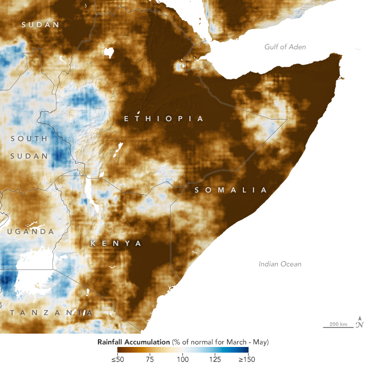
A NASA model describing rainfall in East Africa. With NASA’s Land Information System, researchers can produce detailed models describing complex Earth systems. (Image Credit: NASA)
In the early 2000s, new Earth-observing satellites like Terra, Aqua, and Aura gave researchers access to terabytes of novel data, enabling them to study some of Earth’s most complicated systems in unprecedented detail.
But transforming those vast troves of information into accessible data products remained a significant challenge. ESTO’s Computational Technologies (CT) and Advanced Information Systems Technology (AIST) programs helped a team of researchers from NASA’s Goddard Space Flight Center solve that problem.
Led by Christa Peters-Lidard, the team developed the Land Information System (LIS), a software framework that turns satellite and ground-based observational data into high-resolution models of terrestrial water and energy cycles.
Using machine learning and a highly modular system design, LIS can consume large amounts of raw data and produce predictive models with unprecedented accuracy.
Today, researchers apply LIS models managed by NASA to handle a wide variety of applications, from helping the United States Agency for International Development predict famines to supporting the United States Air Force with detailed weather forecasts.
LIS was one of ESTO’s earliest projects. Co-recipient of the NASA’s 2005 “Software of the Year” award, it quickly became an essential tool not only for NASA researchers, but for Earth scientists around the world.
Subsequent AIST funding helped Peters-Lidard, who currently serves as the Director of NASA’s Sciences and Exploration Directorate, and her team take LIS even further.
A 2005 AIST grant awarded to Sujay Kumar, now a NASA Research Physical Scientist, integrate LIS into a broader sensor web. A 2008 AIST grant created a new, general optimization subsystem for the software framework, while a 2011 AIST grant led to a mission simulation and evaluation platform.
LIS will continue to play a critical role in NASA’s efforts to better understand complex Earth systems. The software will soon help researchers produce a new operational hydrology environment for flood forecasting and process high-resolution data from TEMPO, the latest addition to NASA’s Earth Observing System.