TEMPO
TEMPO, the Recently-Selected Earth Venture Instrument for Daytime Pollution Monitoring, Enabled by Key Early Technology Investments
Andrea Martin, December 2012
![]()
To address the need for frequent, high-resolution pollution data over North America, NASA has selected the Tropospheric Emissions: Monitoring of Pollution (TEMPO) proposal as the first Earth Venture Instrument (EVI) award.
TEMPO, managed by principal investigator Kelly Chance of the Smithsonian Astrophysical Observatory and a team including members from Ball Aerospace, NASA’s Langley Research Center, NASA’s Goddard Space Flight Center, and the U.S. EPA, will provide a spectrometer that collects ultraviolet and visible data on major pollutants including ozone, nitrogen dioxide, sulfur dioxide, formaldehyde and aerosols.
Operating in geostationary orbit on a commercial satellite approximately 22,000 miles above Earth’s equator, TEMPO will be able to collect pollution data covering Mexico, the United States, and Canada at an hourly rate during daytime hours. This is a major improvement in the current frequency capabilities – data can only be collected once a day from a low Earth orbit and at much coarser spatial resolution.
Two ESTO Instrument Incubator Program (IIP) projects have played, and will continue to play, a pivotal role in the development and operation of TEMPO. The GeoSpec (Geostationary spectrograph for Earth and Atmospheric Science Applications) and GeoTASO (Geostationary Trace Gas and Aerosol Sensor Optimization) projects have been critical in bringing together the TEMPO instrument and science team members as they worked to develop airborne prototype spectrometers and the required algorithms for measurement of air quality.
The long-term shared work experience on similar sensors has led to lessons learned that have guided the TEMPO team. Most specifically, the GeoSpec sensor development experience helped to refine the sensor concept necessary for TEMPO.
The work being completed on GeoTASO, an airborne spectrometer for trace gas and aerosol studies, is also contributing to the development of TEMPO. The algorithm sensitivities related to the GeoTASO sensor design will help match the TEMPO sensor design to the algorithm needs.
In addition, GeoTASO’s reconfigurable sensor will test the algorithm performance over a range of parameter values such as optimal spectral sampling and polarization sensitivities which will in turn help dictate the flight sensor parameter choice. This algorithm refinement for GeoTASO will ensure that when TEMPO is launched, the retrieval algorithms will be ready to be reliably applied to the data collected.
Most importantly, when TEMPO is fully operational, the airborne GeoTASO instrument will be available to be used as a validation tool for the TEMPO mission.
ESTO’s long-term investment in developing and prototyping instrumentation has led to valuable experience and knowledge that is necessary for improved Earth observations. Previous and ongoing IIP work has advanced both retrieval algorithms and sensor definition so that the complete measurement system for an instrument like TEMPO can be ready to successfully monitor pollutants.
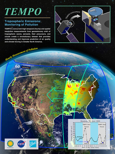
A graphic overview of TEMPO. (Credit: NASA)
CLICK TO ENLARGE
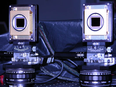
The GeoSpec detector packages. (Credit: Scott Janz, NASA GSFC)
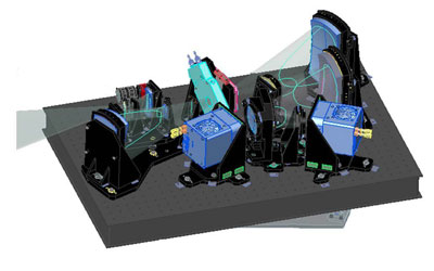 Mechanical drawing of the layout for the GeoTASO instrument.
(Credit: Jim Leitch, Ball Aerospace)