Portable Remote Imaging Spectrometer (PRISM)
PRISM Makes First Flight
June 2012 – Andrea Martin, NASA ESTO
![]()
Coastal regions are complex systems affected by naturally occurring and human induced events. Sediment plumes, algal blooms, tsunamis, and pollutants represent just a few of the phenomena that can alter the coastal waters and their associated ecosystems.
NASA’s Earth observing satellites have long been collecting data related to the oceans and coastal areas. But the satellites cannot provide the resolution needed to fully understand the many components of the waters.
To address the need for higher resolution in time, space, and spectral imagery, NASA’s ESTO, Airborne Science, and Ocean Biology and Biogeochemistry programs have funded the development of the Portable Remote Imaging Spectrometer (PRISM) Coastal Ocean Sensor led by P.I. Dr. Pantazis Mouroulis of the Jet Propulsion Lab (JPL). PRISM’s sensitivity, dynamic range, and polarization properties are specifically designed for the challenges of the coastal ocean environment.
PRISM contains an imaging spectrometer that covers the visible and near-infrared (VNIR) range and a short-wave infrared (SWIR) spot radiometer.
The spectrometer spectral range extends from 350-1050 nm, with a spectral resolution of 3 nanometers. The spatial resolution depends on the altitude and plane speed; it can vary between 0.3 and 16m, while the swath width is 30.8 degrees.
The two-channel (1240 nm and 1610 nm) SWIR radiometer adds information about atmospheric scattering and aerosol properties, enabling more accurate atmospheric correction.
On the week of May 7, PRISM flew in a NASA Twin Otter aircraft for test and calibration over Ivanpah Playa and Lake Tahoe. Data was collected from several flight lines over bright sand, dark water, and special calibration panels. Preliminary data analysis indicates excellent spectrometer performance. The information gathered is also being used to perform any residual adjustments before the scheduled validation flight in July over Monterey Bay.
PRISM instrument delivery is scheduled for October.
For more information on emerging technologies for Earth science, visit the NASA Earth Science Technology Office website.
![]()
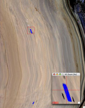
Non-rectified PRISM image from Ivanpah Playa with blue tarp spectrum
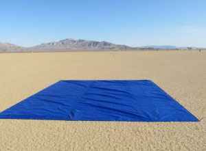
The surface calibration target at Ivanpah Playa
Below: Orthorectified (temporary algorithm) PRISM RGB band image of JPL