New Flash Lidar Technology
Flash LIDAR Technology Shows Promise for Vegetation Science Measurements
August 21, 2009 – Philip Larkin, NASA ESTO
![]()
In October 2008, a prototype Flash LIDAR instrument flew on a series of airborne tests to demonstrate its potential for improved vegetation measurements. The prototype is a precursor to the Electronically Steerable Flash LIDAR (ESFL) currently under development at Ball Aerospace and Technology Corp. with funding from the NASA Earth Science Technology Office. ESFL may soon significantly expand our ability to measure vegetation and forests and better understand the extent of their role in global climate change and the carbon cycle.
LIDAR is already a useful, proven technique for measuring vegetation height and density. But today’s single-beam LIDAR instruments – like the Geoscience Laser Altimeter System on board NASA’s ICESat satellite – lack the ability to scan side-to-side and their measurements are essentially 2 dimensional.
Using a single laser to create multiple beams, the ESFL system is designed to instantaneously sample numerous cross-track ground footprints. This approach provides a traditional intensity measurement combined with a range (distance) measurement to produce a 3-dimensional view of vegetation that shows height, density and shape. The multiple beams are also independently and non mechanically controllable and steerable, allowing for a variety of footprint coverage options – from closely packed to broadly spaced out – to match the science goals.
This type of measurement could help scientists answer a wide range of pressing questions: How much carbon is stored
(sequestered) in a particular forest? What are the global effects of land use change and deforestation on atmospheric carbon dioxide? Is the foliage in a given area concentrated near the ground, at the tree canopy, or vertically distributed? How would a forest fire progress? How much fuel is available? Would a fire reach the canopy of trees or stay near the ground?
An ESFL-like instrument could even address questions related to biodiversity. “Certain types of birds will only nest in certain trees or at certain heights,” said ESFL Principal Investigator, Carl Weimer, of Ball Aerospace. “With a 3-D view, we’d be able to determine whether those habitats exist in particular areas based on the shape and height of the trees.”
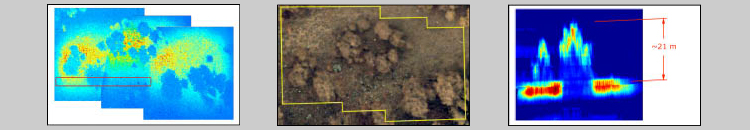
Dr. Weimer and the project team conducted the ESFL prototype test flights over prescribed burn sites in the foothills of Colorado as well as over the Colorado State University’s Agricultural Research, Development and Education Center experimental forest. Burn sites were chosen to establish at the instrument’s ability to measure burned areas and create an estimate of the carbon lost to the atmosphere during the burn.
The flights were carried out from an altitude of 250 m (above ground level) and were designed as a testbed for the LIDAR along with integrated GPS/Inertial Navigation Units for geolocation and a visible camera for context and data fusion. The team is currently comparing the airborne data with ground-truth measurements.
Meanwhile, development and integration continues on several critical components for the final ESFL system. The project team is combining a flash focal plane array, which will digitize the return signal from the multiple beams, with beam steering and beam pattern optimization technologies. Dynamic control of the beams would allow real-time targeting for a particular region of interest and could even be used to avoid clouds. “The flexible steering capability could be used to distribute observations spatially, which would increase confidence in biomass estimates for forested landscapes”, says Michael Lefsky of the Warner College of Natural Resources at Colorado State University.
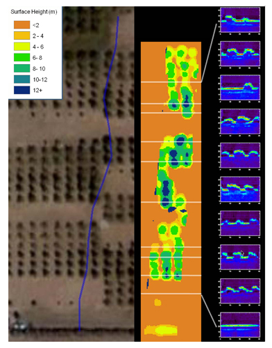 |
At left: processed data from a 2008 flight over an experimental forest at Colorado State University’s Agricultural Research, Development and Education Center (ARDEC). The visible image on the left shows the airplane track (blue). The middle image is the LIDAR intensity return, where orange is ground level and blue represents a height of 12+ meters (see legend). At the right are sectional elevation views that correspond to specific moments along the intensity return track. The data analysis and images used in this example were provided by Michael Lefsky, an Assistant Professor at Colorado State University’s College of Natural Resources.. | |||
More airborne tests flights are planned once ESFL construction is complete, as early as October 2009. ESFL will take data over the same flight plans as the 2008 prototype tests as well as over some new sites. One proposed site is Niwot Ridge, CO, for which there is ICESat data. Another is at a sea-level coastal area in California to test the effect of higher altitude (above ground level) on the divergence of the beams and the beam spot sizes.
ESFL is being designed and developed using lessons learned from previous NASA Earth science LIDAR efforts, particularly the CALIPSO mission. Dr. Weimer hopes that ESFL will soon provide new LIDAR technology options for future NASA missions, such as DESDynI, particularly the advances in multiple, steerable beams and dynamic control. “We have twin goals of both building upon heritage designs and technologies and providing the new capabilities to support NASA with new solutions for space,” he says. “There is considerable positive feedback from the science community that (ESFL) will enable new types of measurements.”
The work is funded by NASA’s Earth Science Technology Office through the Instrument Incubator Program.