NASA software leverages hyperspectral data to better understand climate change
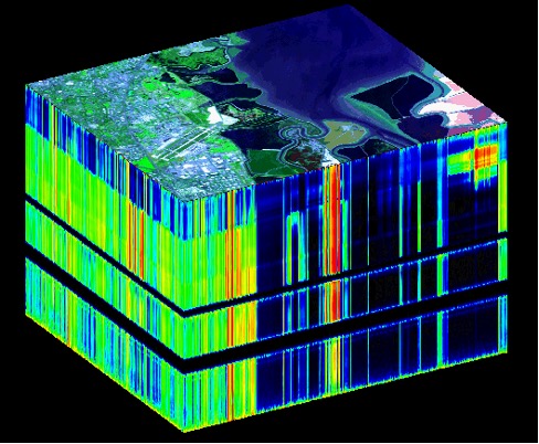
A hyperspectral data cube gathered by JPL’s Airborne
Visible/Infrared Imaging Spectrometer (AVIRIS) instrument depicting part of San Francisco. (Credit: NASA / JPL)
4/28/22 – From masting trees to honey bees, all life on Earth depends on delicate environmental systems to survive. As our climate continues to change, these systems will change as well, dramatically altering the relationship we and other Earthlings have with our planet.
A team of researchers from NASA’s Jet Propulsion Laboratory, the University of Colorado, Boulder, and the University of Wisconsin are teaming up to build an open-source software platform that will help professional and citizen scientists study our changing world more easily.
Led by Philip Townsend, Associate Professor for Remote Sensing and Spatial Analysis at the University of Wisconsin, the team is hard at work on the “On-demand Geospatial Imaging Spectroscopy Processing Environment on the Cloud” (ImgSPEC), which will connect NASA customers with the data sets, algorithms, and cloud-based computing power that they need to transform raw data into accessible data products.
The project will be especially useful for creating imaging spectroscopy data products that use the chemical signatures of Earth’s atmosphere and surface to map things like vegetation trends and the effects that climate change has on Earth’s biology and geology.
ImgSPEC integrates existing NASA-funded technologies (such as EcoSIS and NASA Earth Data Search) into a single system and then connects that system to a cloud-based computing network through an intuitive, user-friendly interface. Working together, these components give users access not only to NASA’s complete collection of Earth science data, but also the computational resources they need to process that data in a timely manner.
Once complete, ImgSPEC will become a crucial building block of both NASA’s Open-Source Science Initiative and NASA’s Surface Biology and Geology (SBG) research efforts.
“We want to democratize the way NASA customers process big data to provide value-added products relevant to their science and decision-making. ImgSPEC reduces the amount of time it takes to move and process big data,” said Natasha Stavros, Director of the University of Colorado, Boulder, Earth Lab Analytics Hub and a co-investigator on the project.
ImgSPEC overcomes two significant barriers currently preventing users from accessing NASA’s imaging spectroscopy data collection, curated over the years by airborne instruments like AVIRIS and spaceborne instruments like Hyperion. One is simply size: imaging spectroscopy data cubes contain large amounts of information, and the kinds of data sets needed to create useful products can be as large as 590 terabytes.
For perspective, that’s more than 9,000 64GB iPhones worth of computer memory.
Another barrier is scale: NASA missions that create data products using these kinds of data sets usually do so on a global scale. While this is extremely useful for observing world trends, it’s less useful for individuals interested in observing finer scale effect like urban heat waves or deforestation in their local communities.
“It isn’t feasible to produce every possible product that could come from a mission’s data set beforehand. We need a tool that allows users at every level to create custom data products on-demand,” said Stavros.
“ImgSPEC will help local communities use NASA data to help mitigate harmful effects of climate change”, said Stavros. For example, a city planner looking to install a greenspace to protect their city from heat waves could partner with an algorithm developer to design ideal data products that locate the part of their city at greatest risk of severe heating and model how well their proposed park would mitigate that risk, and then use ImgSPEC to create those products on-demand with NASA data.
“Without ImgSPEC, that city planner and other folks who aren’t computer scientists wouldn’t have the resources they need to transform these data sets into a useful product,” said Stavros.
Stavros and her colleagues have already demonstrated ImgSPEC’s value for leveraging hyperspectral data to map vegetation foliage traits and fraction cover. Moving forward, they plan to continue preparing ImgSPEC for widespread use by scientists and the general public.
This project was made possible with funding from the Advanced Information Systems Technology Program (AIST), a part of NASA’s Earth Science Technology Office (ESTO).
Gage Taylor, NASA Earth Science Technology Office