Geostationary Imaging Fabry-Perot Spectrometer (GIFS)
Instrument Prototype Demonstrates Capacity for Improved Cloud Characterization in Recent Test Flights
March, 2008
![]()
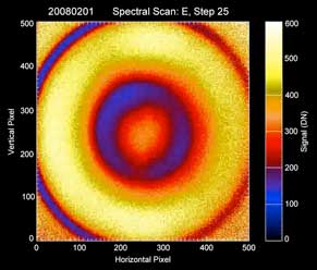
Nadir image taken with the GIFS prototype instrument on board the NASA P3 near Wallops Island, VA, on Feb. 1, 2008. This 400×400-m image of clouds, taken from 21,000 ft, has a spatial resolution of 0.8 m. Concentric circles or rings on the image correspond to different wavelengths of light, with the two dark rings due to molecular oxygen absorption lines near 685 nm. By tuning the interferometer etalons, a sequence of images scans very high-resolution spectral features that contain information about cloud optical properties at every pixel of the image.
Click here to view a short MPEG animation of the GIFS spectral spectral scanning capability from the 2/1/08 flight.Near the end of the animation, the GIFS instrument was measuring the reflected sunlight outside the absorption region, clearly showing its cloud images as they passed by the GIFS field-of-view.
In February 2008, a prototype instrument developed under the ESTO Instrument Incubator Program concluded a series of science and performance test flights on board the NASA P3 aircraft over Wallops Island, VA. The Geostationary Imaging Fabry-Perot Spectrometer (GIFS) instrument is being developed to take measurements of clouds and surface pressure, eventually onboard a satellite in geostationary orbit. Although data from the flights has yet to be fully analyzed, initial returns show promise for the instrument’s measurement technique and spectral tuning capabilities.
Global observations of low-level clouds are critically needed for long-term climate studies. Current measurements from satellite, aircraft, and ground-based instruments (like radar) are limited in their ability to detect some clouds – particularly low level and shallow boundary layer clouds – which are thought to have an impact on the accuracy of global circulation models. The GIFS team is developing and test flying the prototype instrument in part with the aim of demonstrating a significantly improved capacity for these kinds of measurements.
The GIFS instrument, a tunable triple-etalon Fabry-Perot Imaging Spectrometer, is designed to measure the O2 absorption lines in solar radiation reflected off the Earth’s surface. This optical technique can provide data to characterize cloud properties in 2 dimensions. The instrument also potentially provides measurements with spatial resolution, spatial coverage, revisit time, and precision/accuracy that would be difficult to obtain with existing methods.
The GIFS instrument flights also demonstrated a technology technique that could have a number of potential applications. In addition to cloud optical properties, very high spectral resolution GIFS-type measurements could potentially be used to infer the abundance of other trace gases, even those with weak absorption. For example, a GIFS-like instrument operating in the near- and thermal-IR could be used to measure altitude profiles of tropospheric CO, including in the boundary layer, at high spatial resolution, with relevance to both air quality and climate change research. The only modifcations needed are the addition of the proper filters and detectors for the relevant absorption lines.
The GIFS development team flew the instrument prototype on one engineering and five science measurement missions. All five science flights were timed to collect coincident measurements of cloud properties along with either the CALIPSO spaceborne LIDAR or the B200 airborne LIDAR. They were also able to test a newly developed water vapor measurement capability for GIFS on one of the flights that corresponded with measurements from the NASA Aura satellite. Data analysis is ongoing and the team expects to reveal the full results of these flights by the end of the project’s funding in June 2008.