First-of-its-kind satellite data fusion project sets stage for future surface topography and vegetation missions
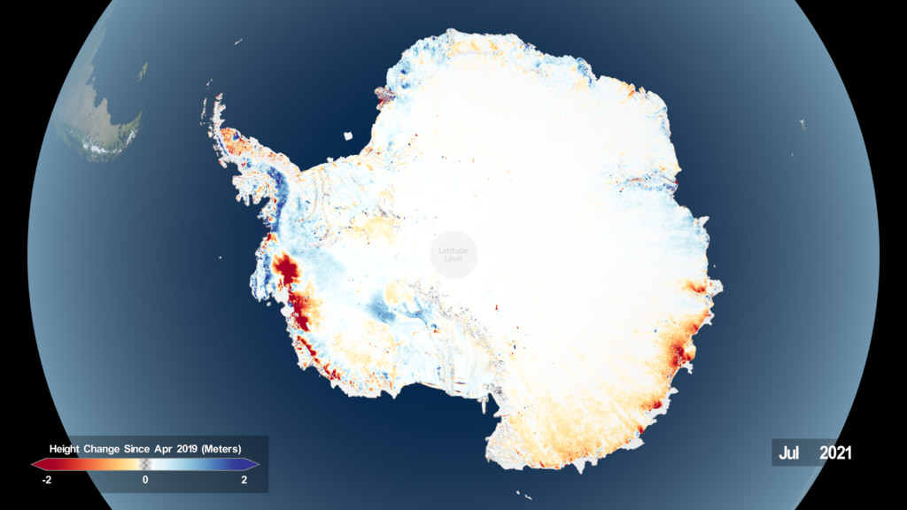
Satellite imagery from NASA’s IceSAT-2 instrument shows Antarctic ice melt since April 2019. A new data fusion project will make it easier for researchers to observe Earth’s topography and track phenomena like shrinking glaciers. (Image Credit: NASA).
02/19/24 – Earth’s cryosphere changes slowly. Ice sheets, glaciers, and perennial snowfields form and fade away over centuries or even millennia, dramatically altering entire continents in the process.
But as climate change continues to raise global temperatures, these frosty formations are disappearing at an unprecedented rate. Since 2002, Antarctica alone has lost more than 140 billion tons of ice annually.
Humans the world over feel the impact of this rapid ice loss. NASA estimates that meltwater from ice sheets is responsible for about one-third of the global average rise in sea level since 1993.
“We need current, accurate measurements for the coastline of the United States, and the world, really, to understand the impacts of sea level rise and flooding moving forward into the next century,” said David Shean, an Assistant Professor of Civil and Environmental Engineering at the University of Washington, Seattle.
Shean and a team of researchers from University of Washington, NASA’s Goddard Space Flight Center, and NASA’s Ames Research Center, are developing new software tools that will help researchers study Earth’s surface with unprecedented accuracy.
Their project, “Advanced Information Systems to Fill STV Gaps: Next-generation Stereo and Lidar fusion and Sensor Technology,” will equip researchers with a collection of open-source algorithms to automatically fuse satellite lidar and stereo photogrammetry data, dramatically increasing the quality of Earth surface topography and vegetation measurements.
The 2017 Earth Decadal Survey, produced by the National Academy of Science, identified surface topography and vegetation as an Incubation Targeted Observable – a subject worthy of high-priority technology investments in preparation for a full science mission within the next decade.
Shean’s work directly addresses this key recommendation, laying the foundation for future NASA missions dedicated to monitoring Earth’s surface topography and vegetation from space.
“That’s really what this incubation project is about: maturing the technologies, developing the workflows to generate the data products we’re going to need, and then trying to figure out the requirements moving forward as we go into the actual instrument design,” said Shean.
Stereo photogrammetry uses multiple photos taken at different angles to reconstruct the 3D shape of objects, while lidar uses pulsed lasers to make sparse 3D measurements with cm accuracy.
Each of these remote sensing techniques can generate detailed models of the Earth’s surface, but merging both types of data makes it easier to produce detailed, more accurate measurements of Earth’s surface at a global scale.
Those measurements will help Shean and his team accomplish another technology goal: to develop algorithms for a ‘ground tracker,’ a new satellite subsystem that will improve the pointing accuracy of both stereo and LiDAR measurements by an order of magnitude using features on the planet’s surface, like boulders or shrubs, as reference points.
To accomplish their work, Shean and his team will perform simulations for different instrument configurations and develop machine learning models to fuse the disparate stereo and lidar data sets automatically.
In addition, these algorithms will help researchers mitigate errors and artifacts caused by subtle satellite vibrations in existing stereo data sets.
“Satellites are always vibrating very, very slightly while collecting data, which introduces pointing error” said Shean. “We’re trying to a build user-friendly software and routines to correct these tiny vibrations in archived stereo images from the last 20 years for many really important places on the earth, so we can measure change with decimeter – 10 cm – accuracy.”
These correction algorithms and the new instrument subsystem could also have applications beyond Earth. Planetary scientists studying the surfaces of other rocky or icy planets might use them to map worlds around our solar system and beyond.
“The technology we’re trying to develop here, this precise pointing algorithm, this ‘ground tracker,’ that should work on Mars too, and it should enable us to make much more accurate measurements of the Martian surface,” said Shean.
But Shean is most concerned with advancing our understanding of Earth’s rapidly changing surface, and how those changes might impact current and future generations.
“I want to apply my skills to work on something that matters for the eight billion people here on Earth right now,” said Shean. “I moved on from Mars research because I wanted to do something that mattered here, to understand what’s happening to our glaciers and ice here on Earth.”
NASA’s Decadal Survey Incubation (DSI) program, a part of NASA’s Earth Science Technology Office (ESTO), funds Shean’s project.
Gage Taylor, NASA Earth Science Technology Office