First Flights for EcoSAR
First Flights for EcoSAR, a New Instrument to Study Carbon-Rich Ecosystems
Andrea Martin, July 2014, andrea.s.martin@nasa.gov
![]()
Carbon, a naturally occurring and extremely abundant element, is exchanged between various sinks or reservoirs – including oceans, soils, vegetation – and the atmosphere in a process called the carbon cycle. Natural events like wildfires, and human-induced activities including the burning of fossil fuels release carbon into the atmosphere. While carbon is safely stored in forests and permafrost, the carbon released into the atmosphere plays an important role in climate change as the greenhouse gasses methane and carbon dioxide.
Even though carbon is such an important piece of the climate change puzzle, much is still unknown about how much carbon is sequestered in terrestrial environments. Estimates of the amount of carbon stored in Earth’s forest range anywhere from 385 petagrams to 650 petagrams. For reference, 1 petagram is equal to 1 billion metric tons. A better understanding of how much carbon is stored in forests and what changes those environments are undergoing can give researchers a better idea of how much carbon could potentially be released into the atmosphere.
To address the need for more accurate and timely measurements of terrestrial carbon-dense ecosystems, NASA’s Earth Science Technology Office (ESTO) has funded the development of EcoSAR, an airborne polarimeteric and interferometric P-band radar instrument.
Temilola Fatoyinbo of NASA’s Goddard Space Flight Center has led the development of EcoSAR. The single-pass radar’s microwaves can look more deeply into vegetation than the more commonly used L-, C- or X- band shorter wavelengths. With P-band’s longer wavelength, the radar can penetrate more deeply into forest canopy to measure the forest volume and woody density, the biomass.
EcoSAR’s P-Band capabilities can provide greater coverage, higher resolution and higher accuracy tree height measurements in forests than existing radar instrumentation. Canopy height of very tall forests will be measured to within 1-meter accuracy while the above ground woody biomass will be measured to an accuracy of 20% with EcoSAR.
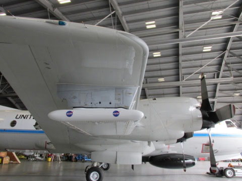
The instrument itself consists of the radar electronics unit that is kept on racks inside the fuselage of a P-3 aircraft, a radar digital unit capable of performing real-time configuration and data archiving, and two antennas mounted on either wing of the aircraft. By spacing the antennas this way, EcoSAR is able to achieve 25-meter interferometry (a technique where the received measurements are superimposed to allow researchers to see slight variations in the surface of what is being studied) with a single pass instead of flying repeat passes over the same area.
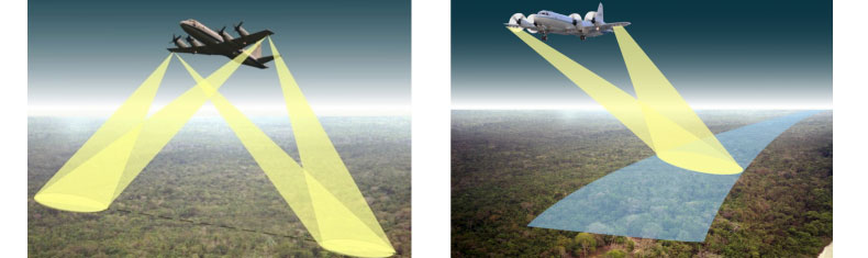
At left: The EcoSAR instrument has the capability of imaging with two antennas on one or both sides of the flight track simultaneously. Right: The two identical P-band antennas that are mounted underneath the wingtip of the P3-Orion aircraft can perform a technique called single-pass interferometry.
(Image Credit: Fatoyinbo, NASA)
The instrument can operate in a high-resolution science-mode with 1 meter-resolution at 200 MHz in areas of scientific interest like the remote forests being studied, or at a lower 5- to 25-meter resolution (6 to 30 MHz) where there could be restrictions on P-Band frequencies.
During the Month of March in 2014, EcoSAR made its inaugural flights on a NOAA P-3 aircraft. Departing from MacDill Air Force Base, the first flight was over Andros Island in the Bahamas. Later in the month, EcoSAR flew from MacDill over Mexico, Belize, Honduras, Guatemala, Costa Rica and El Salvador to collect measurements in Costa Rica. Additional EcoSAR flights departing from Liberia, Costa Rica, collected science data over the dense tropical forests of that country.
After the successful science flights, EcoSAR returned to Goddard Space Flight Center in Maryland where the team is processing and analyzing the 8 Terabites of raw data that were collected as part of the flight campaign.
(Image Credit: Fatoyinbo, NASA)
In addition to data analysis, the instrument team is testing the different modes in which the instrument can function to collect data to assess which modes work best for specific flight and environmental conditions. They are also updating the instrument based on flight experience to refine and quicken onboard processing.
EcoSAR’s measurements can tell researchers much about the extent of terrestrial forests and the changes to which these environments are prone. From flooding, wildfires to deforestation, understanding these high biomass ecosystems and the changes they are going through will give climate researchers a better understanding of how much carbon these environments store and how much carbon can be, or is being, released as the ecosystem faces natural and human caused changes.
In the future, Fatoyinbo plans on flying EcoSAR over different ecosystems from dense forests already sampled to test the instrument’s capability for permafrost, ice and snow depth measurements.
P-Band wavelengths can also be useful to study permafrost soil. It is estimated that twice the amount of carbon that is stored in the atmosphere can be found locked away in permafrost. But as the climate warms, permafrost is melting allowing the previously sequestered carbon to be released into the atmosphere. Currently, the extent of permafrost thawing is unknown. EcoSAR measurements could more clearly delineate the areas that are undergoing change. Data like this can give scientists and modelers better information about the rate of carbon being released into the atmosphere for their research on climate change.
EcoSAR’s development is a step forward in being able to more accurately understand Earth’s carbon rich environments. For the first time, this data can be collected by a polarimetric, single pass, interferometric system which has the advantage of ‘seeing’ through clouds and the ability to cover larger areas on the ground at higher resolution than was able with previous technology. The new NASA-funded and developed instrument can give climate scientists, policy makers, land managers and others new, highly accurate data for use in studying climate, ecosystem changes, and atmospheric science.