Extreme Storm and Flooding Forecasts Improved by Sensor Network
Extreme Storm and Flooding Forecasts Improved by Sensor Network
Andrea Martin, April 2013
![]()
Southern California is known for its always-beautiful weather. But not all days are postcard perfect. Extreme weather events like North American Monsoons and atmospheric rivers – streams of high atmospheric water vapor that carry high amounts of moisture from tropical and mid latitudes – both bring large amounts of rain and potential flooding to the United States’ west coast.
Accurate forecasts of these weather events can be difficult. Weather forecasters often depend on several models. But models can disagree, leading to inaccuracies. In the area around Southern California, including Mexico and the Pacific Ocean, there are very few meteorological observations. Cities like San Diego, Tucson and Phoenix are spread too far apart to accurately locate the boundary between dry and moist air. Satellite data can help to estimate the moisture content found in atmospheric rivers, but with infrequent overpasses there are data gaps.
With conflicting models, widely-spaced meteorological stations, and high-latency satellite data, forecasters often use real-time data and observations to issue weather alerts that a severe situation could, or is developing. Because of this, severe weather comes with very little warning, so proper preparations to protect life and property usually cannot be made.
But a new ESTO-funded project is looking to change that. The Next-Generation Real-Time Geodetic Station Sensor Web for Natural Hazards Research and Applications project is developing a real-time sensor web that can effectively address many of the data gap concerns.
GPS Meteorology uses co-located air pressure and temperature measurements to accurately estimate precipitable water vapor. As part of the project, PI Yehuda Bock of Scripps Institution of Oceanography, Co-I Angelyn Moore at Jet Propulsion Laboratory and their team have enhanced a GPS Meteorology network by combining the data from 27 existing GPS stations in Southern California with meteorological data from onsite or nearby meteorological instruments. This additional data has been added to the NOAA Earth System Research Lab’s (ESRL) GPS meteorology station network in Southern California.
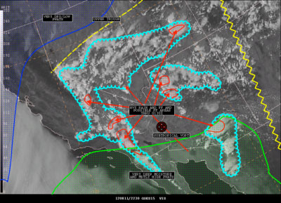
This annotated visible satellite image shows potential for storms in southern California due to the North American Monsoon. (Credit: the NOAA Satellite and Information Service)
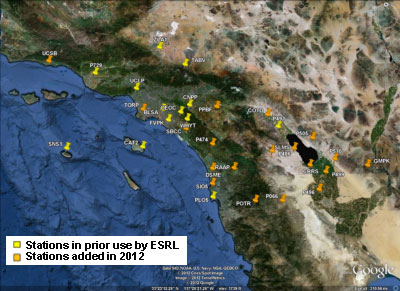
The prototype network to be fitted with a Geodetic Module for onsite PWV estimation. Stations added to ongoing NOAA ESRL operations in the first phase of the project are shown in orange. (Credit:Y. Bock)
The ESRL network data – including the data collected by the 27 new GPS Meteorology stations added by this project – are being assimilated into two NOAA weather models – RAP, with 13 kilometer horizontal resolution every hour and LAPS, with 3 kilometer horizontal resolution every half hour. The addition of the 27 stations has led to an approximately 50 percent decrease in precipitable water vapor uncertainty for Southern California.
The more-accurate RAP and LAPS models were used by the Southern California Weather Forecasting Offices during the 2012 North American Monsoon Season to forecast precipitable water vapor – which can lead to better forecasts of rain amounts and flooding risks.
In the future, the Geodetic Station Sensor Web project team will install and test geodetic modules at each of the 27 new GPS Meteorology Stations that have been incorporated into the ESRL. The modules will use precise positioning and micro electro mechanical system meteorological observations combined with a Kalman filter – an algorithm that uses measurement series over time to estimate an unknown. In this case, the unknown is precipitable water vapor.
These estimates will then be transported to NOAA’s technology infusion partners, the National Weather Service in Los Angeles/Oxnard and the San Diego Weather Forecast Offices. The ESRL in Boulder, Colorado, will also incorporate the data into operational and research products.
Bock has designed this sensor network to operate in a very narrow bandwidth. Typically, in the time leading up to, during, and after a major disaster, communication is difficult. But by operating in a narrow bandwidth, like the one used by the geodetic modules, data can be reliably transmitted when it is needed the most.
Extreme weather will not be the only natural hazard that the sensor-network is concerned with. GPS stations can sense and relay any vertical or horizontal displacement in the ground. Displacement measurements are useful for earthquake and tsunami research and applications like forecasts or warnings.
Forecasting weather, especially extreme weather, can be a difficult undertaking in complex environments with limited observations. But Bock’s geodetic sensor network is adding valuable information to close the data gap. Scientists, first responders, and other decision makers can save lives when armed with the accurate scientific data to alert the public to possible danger one to two minutes before an earthquake or tens of minutes before a tsunami and as much as several hours before storms or flooding. The Next-Generation Real-Time Geodetic Station Sensor Web for Natural Hazards Research and Applications project can provide the data necessary for the models that forecasters and decision makers use to issue such alerts to protect life and property.