SensorWeb 3G Project
Sensor Web Project Generating Buzz and Benefiting Society
February 12, 2010 – Philip Larkin, NASA ESTO
![]()
SensorWeb 3G – an ongoing project that couples satellite, airborne, UAV, and in-situ sensors with science models and advanced software – is proving the value of fully-integrated, real-time Earth observations and providing a glimpse of how future Earth science systems might function. It is also producing a host of pilot projects and applications that are being used today for societal benefit.
Led by Principal Investigator Daniel Mandl of the NASA Goddard Space Flight Center, SensorWeb 3G (or third generation) is focused on natural hazard detection and response, particularly floods and wildfires, but the technology could be applied to nearly any remote sensing application. The project is providing lessons that can affect future mission design as well as advance cross discipline science interoperability.
SensorWeb 3G is demonstrating rapid, low cost ways to network and control various sensors and instruments into ‘webs’ that combine the multiple observations with models to give a more complete view of real-time situations. These sensor webs enable users to easily define scripts that orchestrate and autonomously trigger observations from space, airborne, and in-situ instruments
in response to unfolding events. The observations are often combined with models to provide users with better and more rapid situational awareness as well as forecasting capabilities.
NASA’s EO-1 satellite is being used to prototype many of these capabilities, which have already helped to automate the EO-1 mission, and approved users around the world can now trigger EO-1 observations using a JAVA client.
End-user interfaces are designed so that intimate knowledge about the sensors, or how they work, is not necessary, making the systems accessible and useful for firefighters, flood responders, NGOs and governments in the developing world. SensorWeb 3G is running numerous pilot projects, working with some 40 partners worldwide.
In 2009, the project prototyped various capabilities in demonstration mode and provided valuable satellite imagery to first-responders or post-event analysts during several major events: the Station Fire in California, Australian fires and floods, the Red River flood, the Samoa tsunami, mudslides in Honduras and Guatemala, and Hurricane Jimena in Baja Mexico.
The project team is also participating in a variety of natural hazard programs and workshops around the world to further infuse the SensorWeb 3G concept into regional and continental disaster management systems. For example, they are developing a concept for a Disease SensorWeb, which could trigger early warning for certain diseases based on changing vegetation and environmental conditions.
In 2008, R&D Magazine named a prior version of the project, Sensor Web 2.0, to its “Top 100 Innovations of 2008” list.
The SensorWeb 3G project is funded by the NASA Earth Science Technology Office through its Advanced Information System Technologies program.
![]()
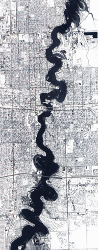
NASA’s EO-1 satellite captured this clear, cloud-free image of Fargo, ND, on Saturday March 28, 2009, at the height of the Red River flooding, and provided the data to disaster monitoring personnel via USGS / EROS in Sioux Falls, SD. This near real-time data acquisition of the flood was made possible, in part, by the activation of the sensor web technology in response to a manual request.
+A larger, high res version of this image is available at the NASA Earth Observatory website