Novel NASA sensor incorporates AI into lightweight camera for observing fires
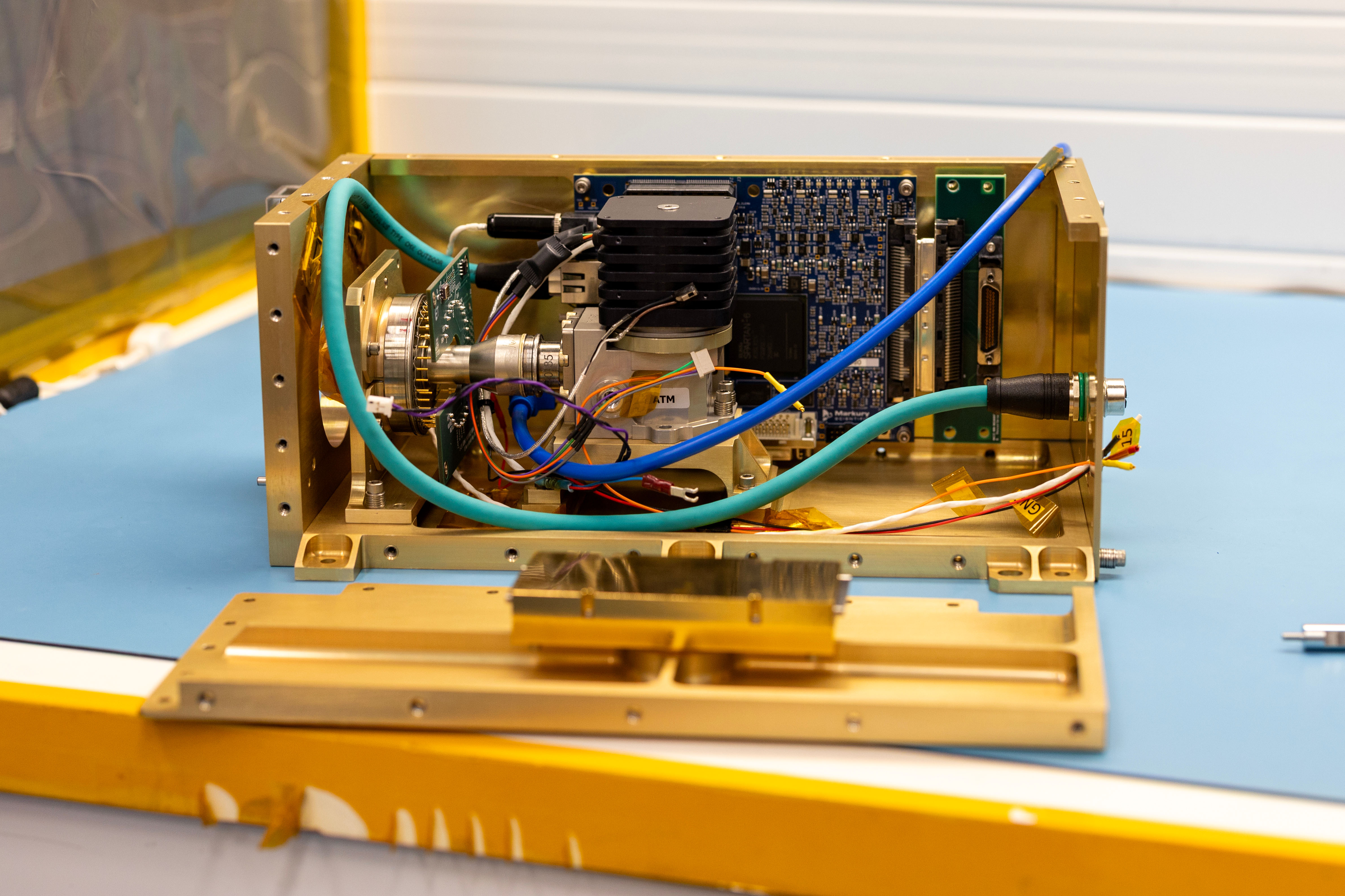
A photo of the Compact Fire Imager (CFI). CFI will help first responders manage wildfires more efficiently. (Image Credit: NASA/Paul Padgett).
2/16/26 – Researchers at NASA’s Goddard Space Flight Center (GSFC) are developing a compact infrared camera that leverages AI to help first responders manage wildfires more efficiently, setting the stage for future space missions dedicated to observing fires.
Developed with support from NASA’s Earth Science Technology Office (ESTO), the “Compact Fire Imager” (CFI) will detect heat signatures across 6 infrared bands within the shortwave, midwave, and longwave spectral regions, which is a huge range for a sensor the size of a shoebox. Using advanced AI algorithms, CFI will also be able to automatically identify and downlink data sets that are particularly useful to firefighters, reducing the amount of time it takes to get mission-critical information into the hands of people who need it most.
“We urgently need on-orbit assets for tracking wildfires, and this technology development project is designed to spur that work,” said Doug Morton, Earth System Scientist at GSFC and principal investigator (PI) for CFI.
From space, a constellation of small satellites equipped with instruments like CFI could provide firefighters with real-time data describing the temperature of active wildfires, filling gaps in current satellite coverage and delivering critical data when high winds or other adverse conditions ground airborne monitoring assets.
CFI would also be useful aboard airborne platforms, like High Altitude, Long Endurance (HALE) drones or balloons. HALE aircraft can stay aloft for days at a time, providing wildfire managers with a powerful tool for patrolling fire-prone environments and detecting small fires.
Several features distinguish CFI from other thermal sensors. First, CFI uses a novel spectral filter assembly to measure heat signatures across the infrared spectrum, from shortwave to longwave. This allows CFI to detect cooler, smaller fires while simultaneously observing hotter, larger blazes.
Second, CFI leverages cutting-edge semiconductor chips to run AI algorithms that will locate time-sensitive fire data and automatically send it to wildfire managers on the ground. Once complete, CFI could notify first responders before a fire grows out of control.
“Our instrument carries an NVIDIA Jetson processor, so we can demonstrate onboard AI processing to identify and then strip out fire information for immediate downlink,” said Morton.
Morton explained that his team is working on two CFI prototypes, one for compact spacecraft and one for small, autonomous drones. Together, an airborne CFI could validate measurements gathered by a spaceborne CFI, ensuring the on-orbit sensor delivers reliable data.
This past summer, Morton and his team flew their airborne CFI prototype as part of the MAGIQ and SARP-East campaigns, targeting wetlands, sites that had recently experienced a burn, and other forested regions. Next, the team plans to fly aboard NASA’s ER-2 research plane as part of the upcoming INSPYRE EV-S campaign.
Morton also hopes to fly CFI aboard an autonomous drone or balloon during a controlled burn in the near future, which would help his team ensure CFI is ready to detect and characterize real-world fires.
“It’d be a good opportunity to test our software and our instrument to make sure we are ready for a dedicated fire campaign as part of NASA’s FireSense Program,” said Morton.
ESTO’s FireSense Technology (FireTech) program funds Morton’s work. As a key element of NASA’s FireSense program, FireTech bridges the gap between technology producers and end users, validating new tools for wildfire management through comprehensive field campaigns and working closely with wildfire managers to make sure these tools suit their needs.
Gage Taylor, NASA Earth Science Technology Office