New Interferometer (GLISTIN-A)
New Interferometer to Aid In Ice Topography Measurements
Andrea Martin, October 2012
![]()
On September 16, 2012, Arctic sea ice levels reached a new minimum, surpassing the previous low that was met during September of 2007 by nearly 300,000 square miles. Sea ice is just one factor in studying climate change, but it is a major indicator of a warming climate. While it is important to know the coverage of ice on land and sea, it is also necessary to discern the thickness and topography of the ice.
To more fully understand the role ice plays in climate, NASA’s planned decadal survey mission ICESat-2 (Ice, Cloud, Elevation Satellite-2), will collect valuable measurements on ice-sheets and sea-ice, but under-sampling due to spacing, especially in glacial areas could lead to ice-volume estimation errors.
Airborne instruments can bridge the data gap produced by under-sampling. During the International Polar Year (IPY) in 2009, a swath-mapping airborne sensor flew over Greenland collecting data for high-resolution ice-surface topography maps to gain a clear picture of ice volume.
Now an ESTO-funded task is taking what was learned during the IPY campaign, and developing an improved, permanently-available, Ka-band UAVSAR configured interferometer. The Airborne Glacier and Land Ice Surface Topography Interferometer (GLISTIN-A), developed by PI Delwyn Moller of Remote Sensing Solutions, has modified the IPY interferometer with a new Ka-band up- and down-converter chain and a state-of-the-art solid state power amplifier. These improvements will allow more peak transmit power and the ability to ping-pong, or for the antenna to both transmit and receive which improves the vertical accuracy of data. GLISTIN-A will also have swath coverage of at least 10 km as compared to the 7.5 km swath of the IPY instrument.
On August 8th and 13th, 2012, GLISTIN-A flew on a NASA Gulfstream III (G-III) aircraft for initial engineering flights over the Rosamond Calibration Array in California. The first flight was conducted at a series of altitudes to test instrument sensitivities and the various operation modes including the new ping-pong ability.
The flight on August 13th was flown over the corner reflectors at Rosamond at a nominal altitude and operation mode. From there, the G-III flew GLISTIN-A in long lines over California’s central valley to provide phase screen data and stability information, as well as a validation and characterization of the system calibration loop.
The August engineering flights proved successful. Data collected was used to produce imagery and interferograms.
The UAVSAR configuration of GLISTIN-A can be transitioned for flight on the GlobalHawk. (GLISTIN-H) – planned for Spring of 2013 – where it will be able to provide quality data on ice topography in areas that are often deemed too remote for in-depth study. The information the interferometer collects will compliment the data collected by ICESat-2 to provide the cryospheric science community with timely and complete coverage of the polar regions.

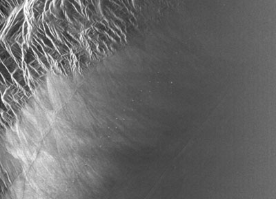
Above: first-look, uncalibrated elevation data obtained by GLISTIN over the Rosamond Lake area from an altitude of about 9.2 km. (credit: D. Moller)
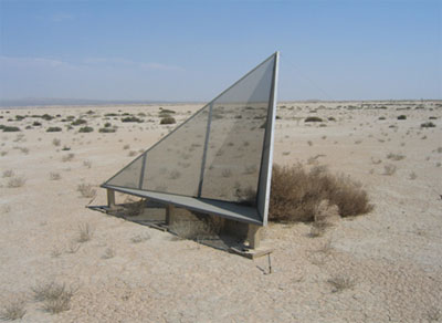
Below: a GLISTIN image of the Rosamond calibration site from 8/8. The trihedral corner reflectors (shown at bottom) are visible in a line proceeding from the bottom left to top right. (credit: D. Moller and JPL)