InSAR Scientific Computing Environment (ISCE)
New Software to aid in Disaster Research and Time-series Imaging
Andrea Martin, March 2013
![]()
Natural disasters such as earthquakes, landslides and volcanic eruptions can be studied by looking at displacement in the Earth’s surface both prior to and after a natural disaster occurs. Studying displacement can aid in the preparation for, mitigation of, and recovery from natural hazards, which often result in serious human and economic losses.
To better understand hazards and global change – to characterize their effects, understand the risks and analyze the Earth’s response to a changing environment – the Decadal Survey called for the DESDynI (Deformation, Ecosystem Structure and Dynamics of Ice) mission. A DESDynI-like mission would gather unprecedented amounts of high quality Interferometric Synthetic Aperture Radar (InSAR) data – an extremely useful instrument for measuring surface displacement that will allow for 4-D models of the Earth’s surface, where the fourth dimension is time. Time series measurements of change are key to not just disaster research, but also the other disciplines that could be supported by DESDynI including ice sheet studies and sea level change, the effects of climate change and land use on habitats and the Earth’s carbon budget, and for monitoring the movement of fluids related to hydrocarbon production and groundwater.
Current InSAR data processing capabilities are not adequate for the volume and quality of data that DESDynI and similar international missions will be returning. The Repeat Orbit Interferometry Package (ROI_PAC) is the most widely used publicly available software for this type of data processing, but it does not easily allow for the incorporation of new and evolving processing techniques. The Uninhabited Aerial Vehicle Synthetic Aperture Radar (UAVSAR) community has their own highly accurate method of processing data, but it does not include all the functionality and flexibility needed for the spaceborne applications DESDynI data can support.
To bridge this gap, ESTO funded the next generation of InSAR processing technology, the InSAR Scientific Computing Environment (ISCE) – an open source, modular software framework capable of supporting the geophysical research communities’ needs.
Led by Principal Investigator Paul Rosen of NASA’s Jet Propulsion Laboratory, ISCE was developed based on the requirements for future capabilities detailed by the InSAR data processing and data modeling community. By first clearly understanding the requirements, a framework for ISCE could be efficiently developed. New algorithms, some with heritage from ROI_PAC, were created by ISCE team members at Stanford University, and inserted into the framework developed at JPL. Modules for adaptability were then added. After testing and feedback, ISCE was completed and is now being used by the research community.
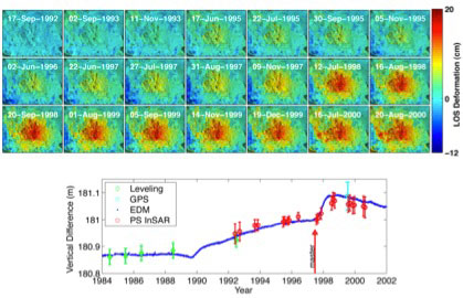
This time series of images depict the decadal-long uplift of Long Valley Caldera near Mammoth, California due to magma below the surface (Courtesy H. Zebker, Stanford University). The ISCE software allows efficient and systematic processing of large quantities of data for such time-series analysis. The profile shows good agreement at a point on the ground between the radar-derived result and other ground-truth observations.
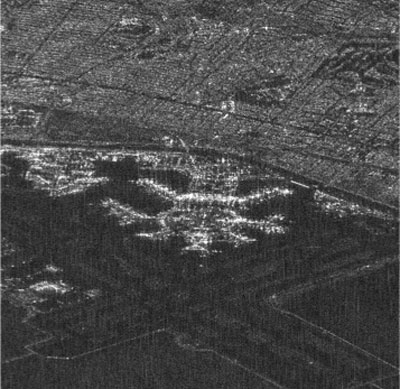
This image is a radar view of San Francisco Airport as processed through the ISCE software. The crossed pattern at the bottom is the radar-dark airport runways. The ISCE image-focusing module is parallelized using OpenMP directives for speed.(Credit:P. Rosen)
While ISCE was developed for the specific needs of current and past spaceborne data, its modular design will allow easy integration of new processing modules to enable the software to be used for DESDynI’s and other future InSAR data sets – airborne and spaceborne, US and international. A major advantage of ISCE is that it was created for users of all skill levels. Imaging novices can use the software for straightforward applications by executing predefined recipes, while the expert user could use and adapt the software allowing for more advanced functions.
In addition to increased usability, ISCE is more accurate and can process data faster than the current processing tools. The previous software code often had geolocation errors of up to several hundred meters. With ISCE, the more reliable and accurate code has reduced these errors to sub-pixel level, greatly facilitating automation of processing many data sets in a common coordinate system. ISCE’s processing speed is as much as a factor of 10 faster than ROI_PAC. Not only is ISCE reliable and fast, it is flexible. The software can be used on many platforms – both desktop and laptop computers operating with Linux, Unix and MacOS, as well as massively parallel supercomputers.
The success and popularity of ROI_PAC has meant that there is a built-in user-group that is ready for the faster, more accurate, and adaptable ISCE. It is anticipated that ISCE will support data processing from all of the InSAR missions flown in the next decade. Even now, years before DESDynI could be launched, based on the current InSAR measurements and other multi-sensor data sets, ISCE has been adopted by UNAVCO, a consortium that facilitates geoscience research using geodesy. ISCE code has been delivered to UNAVCO and posted on their website for download through a free-for-research agreement.
ISCE can be, and is, used by researchers to better understand the movements of the Earth’s surface over time to shed light on hazards such as earthquakes, landslides and even volcanic eruptions. The software is also used to track glacier and ice sheet motions, changes in subsurface groundwater and in monitoring the fluids associated with oil and gas drilling – all of which are changes that can impact economics, resource management, and an evolving environment. The improvements in data processing speed, the reduction in geolocation errors, the involvement of the user community in the development of ISCE, and the adaptable nature of the software are key factors in its current and continued success.