Improving Land Surface and Weather Predictions using Optimization and Uncertainty Estimation Tools
Improving Land Surface and Weather Predictions using
Optimization and Uncertainty Estimation Tools
August 2012 – Andrea Martin, NASA ESTO
![]()
Land-use and water resource managers – the people responsible for the management of use and resource topics including agriculture, forestry, land development, irrigation, and more – often make their decisions based on information calculated by specialized computer models and simulations. These models are structured around clearly defined parameters and high quality observational data. NASA’s Land Information System, or LIS, is one of the modeling tools available.
As NASA continues to provide data to answer the question of how the Earth system is changing, a better understanding of our Earth’s land systems will play an essential role in improving predictions and forecasts.
LIS is a software framework for land surface modeling and data assimilation that uses the many land surface observations gathered by NASA satellites. The data assimilation tools included in LIS produce estimates of hydrologic model states by incorporating remotely sensed observations. But the techniques of the data assimilation tools assume that model state predictions are unbiased relative to the observations. As a result, additional techniques are needed for the removal of such systematic errors prior to incorporating these observations.
![]()
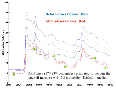
The range in uncertainty prior to (blue) and after (red) consideration of airborne Push Broom Microwave Radiometer (PBMR) observations of surface soil moisture (green points) are evaluated for the Walnut Gulch watershed in the southwestern U.S. during the Monsoon ‘90 Experiment, using LIS-UE. The considerable initial LSM simulation uncertainty—approximately ½ of the dynamic range of soil moisture– is reduced roughly five-fold with the availability of the remote sensing data.
A recently completed ESTO Advanced Information Systems Technology (AIST) project addressed this issue by designing and implementing optimization and uncertainty modeling tools to enhance LIS.
The development of LIS-Optimization (LIS-OPT) and LIS-Uncertainty Estimation (LIS-UE), led by P.I. Christa Peters-Lidard of NASA’s Goddard Space Flight Center, is consistent with the software architecture of the existing LIS framework. The new infrastructure augments the existing data assimilation to improve the modeling of land surface and land surface-coupled systems using both parameter estimation and uncertainty estimation.
LIS-OPT was developed to identify parameter values to best match predictions and observations while LIS-UE was developed to generate a random set of parameter values that are consistent with the known observations. Decision makers, when using the LIS-OPT and LIS-UE tools, will be able to better understand the characterization and associated uncertainties involved in the environmental prediction they are trying to produce.
To test LIS-OPT, the project team conducted case studies and observation system simulation experiments (OSSE) to compare the LIS outputs before and after the inclusion of LIS-UE to more fully understand uncertainty in the models.
First the project team conducted a case study on the Walnut Gulch Experimental Watershed on the values of soil hydraulic properties, a key parameter of land surface models. The first OSSE the team completed focused on the Walnut Gulch Case study to quantify the change in uncertainty as a potential way to improve land data assimilations. In the original case study, using only LIS-OPT to estimate parameters, the uncertainty was 20%. With the inclusion of LIS-UE in the model, which used observations to refine hydraulic property parameter distributions, the uncertainty was reduced by 60 to 70 percent.
Because the Walnut Gulch case study covered data from a limited time, this OSSE highlighted that the LIS-OPT used in conjunction with LIS-UE could be a useful strategy for mitigating bias prior to assimilating data sets from new missions covering only a short period of time. This could mean that new mission data, like the data that will be collected as part of the future SMAP mission, will be available for parameter refinement soon after soil moisture data is collected as opposed to waiting for a longer data record to accrue.
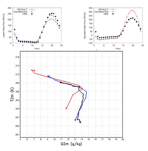
With promising soil hydraulic property data experiments completed, the team looked into another common model, the Weather Research and Forecasting (WRF) model to simulate coupled land-atmosphere interactions during wet-dry extremes.
Surface flux observations employed by LIS-OPT to improve the land surface model parameters led to more accurate predictions of not only the fluxes themselves, but also forecasted weather such as near-surface temperatures and humidity levels. Similar to the experience with soil hydraulic properties for land surface models, the LIS-OPT techniques can lead to more accurate models for land-atmosphere coupled systems.
The project team also conducted a Landslide OSSE where LIS-OPT was applied to a prototype landslide model to estimate areas where landslides may occur in near real-time using TRMM rainfall data products as inputs. With the use of LIS-OPT, the probability of detection increased from a very low 4.2% to 20.8% while the false alarm ratio was decreased from the original 99.1% to 88.7%. This shows a major improvement in more accurate landslide forecasts that could protect life and property.
With the AIST 08 project now completed, Peters-Lidard has been awarded a new AIST 11 project to develop mission simulations and an evaluation platform using NASA’s LIS and the Land Surface Verification Toolkit. The platform will have the ability to easily conduct OSSEs that can demonstrate and quantify Earth observations to improve terrestrial hydrologic science and applications.
—
For more information on emerging technologies for Earth science, visit the NASA Earth Science Technology Office website.