Hyperspectral Thermal Emission Spectrometer (HyTES)
HyTES Successfully Completes First Test Flights
July 2012 – Andrea Martin, NASA ESTO
![]()
The planned Decadal Survey mission, HyspIRI (Hyperspectral Infrared Imager), will collect data to study the Earth’s ecosystems, disasters such as volcanic eruptions and wildfires, and changes in the land surface. To gather the required data for these studies, HyspIRI will utilize a spaceborne Thermal Infrared (TIR) imager as one of its two major instruments.
ESTO has funded the development and testing of the airborne Hyperspectral Thermal Emission Spectrometer (HyTES) to minimize the risk involved in developing a new spaceborne TIR imager for HyspIRI. HyTES data will be used to help HyspIRI scientists and engineers determine the optimal band locations for the TIR instrument and will also be used by the science community to gather high-resolution surface temperature and emissivity measurements for a variety of studies such as observing thermal and gas anomalies from volcanoes.
HyTES, led by Principal Investigator Dr. Simon Hook of NASA’s Jet Propulsion Laboratory, successfully completed its first test flights on board a Twin Otter aircraft flown between Grand Junction, Colorado and Burbank, California the week of July 16, 2012. Initial engineering data were acquired near Grand Junction. Based on an evaluation of those datasets, science datasets were acquired between Grand Junction and Burbank. They include acquisitions over different surface types and gas emissions (sulfur dioxide, methane, ammonia) to determine whether HyTES can be used for gas studies.
HyTES offers both high spatial and spectral resolution, a feature not found on current NASA hyperspectral thermal imagers. The instrument also boasts a compact design including a Dyson spectrometer, curved grating, precision slit and QWIP detector.
Other features of HyTES’s include 256 spectral channels with a spectral range of 7.5-12 micrometers – a valuable range for Earth observations. The pushbroom spectrometer covers 512 spatial pixels over a 50-degree field of view with a noise equivalent delta temperature of about 0.2K
The success of HyTES’s first test flights indicates that this instrument will continue to be a valuable resource for refining the measurement requirements for HyspIRI’s TIR instrument. HyTES data will also be a valuable resource for the science community to use in various ecosystem and natural disaster applications
—
HyTES was funded as part of ESTO’s Instrument Incubator Program (IIP) 2007 solicitation.
For more information on emerging technologies for Earth science, visit the NASA Earth Science Technology Office website.
![]()
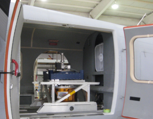
Above: The HyTES instrument on board the Twin Otter aircraft . (image credit: S. Hook)
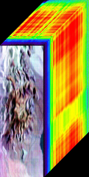
Below: Cuprite, NV , as seen by HyTES on July 20, 2012. Three bands – 150 (10.08 µm), 100 (9.17 µm), and 58 (8.41 µm) – displayed as RGB respectively as an image cube. (image credit: S. Hook)