HAMMR
First Engineering Flights of a New Microwave Radiometer to Measure Humidity
Andrea Martin, September 2014, andrea.s.martin@nasa.gov
![]()
HAMMR, the High-frequency Airborne Microwave and Millimeter-wave Radiometer, completed its first engineering flights in early July 2014. The internally-calibrated, wide-band microwave instrument was developed by PI Steven Reising of Colorado State University, in collaboration with JPL and UCLA, to demonstrate wet-path delay measurements with much higher spatial resolution than current measurement capabilities allow.
Current sea surface height altimeter measurements utilize microwave radiometers operating at centimeter (cm) wavelengths to correct for errors in the speed of the radar signal that occur because of changes in humidity between the satellite and the surface. If humidity, the amount of water vapor in the atmosphere, is not accurately characterized, it skews the data enough to make sea surface height measurements inaccurate, causing an error known as wet-path delay.
Radiometers have been used successfully to measure this wet-path delay on radar altimeter missions for more than two decades, but the currently-used cm-wavelength radiometers provide measurements that are valid only over large water bodies, such as the oceans. These instruments cover a large measurement area, or footprint, on the surface, causing errors within 25 to 50 km from the coasts, a key zone for marine activity and aquatic life, where reliable sea surface height measurements are critically needed. This large footprint also makes it difficult to accurately study the height of inland bodies of water, such as lakes and rivers, which are typically much smaller than the radiometer measurement area.
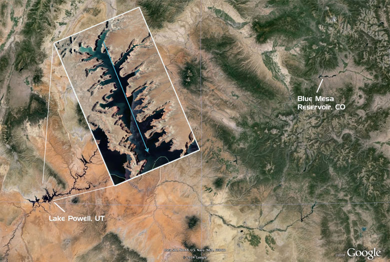
On Wednesday, July 9, HAMMR had a two-hour instrument checkout flight over Blue Mesa Reservoir in Colorado. On July 10th and 11th, HAMMR made more extensive engineering flights totaling approximately 12 hours over Lake Powell in Utah. Lake Powell was chosen as a large inland body of water with a number of clear land-to-water transitions. The inset map shows one of the flight lines over Lake Powell. (Image credit: Google Earth)
HAMMR successfully completed its first engineering flight on July 9, 2014 onboard a Twin Otter aircraft. The instrument incorporates the currently-used cm-wavelength microwave channels (18.7, 23.8 and 34.0 GHz) and provides enhanced capability by adding higher frequency millimeter (mm)-wavelength channels at 90, 130 and 166 GHz. Operating at mm-wavelengths, as HAMMR does, enables 5 to 10 km or better resolution from space, greatly improving the performance of radar altimeters in the coastal region and over inland water bodies.
HAMMR has additional channels at 118 and 183 GHz, for determining the vertical distribution of temperature and water vapor.
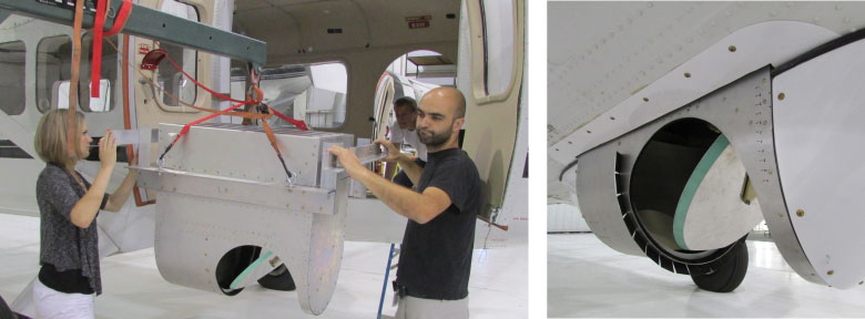
Above left: HAMMR team members Torie Hadel and Xavier Bosch-Lluis install the instrument into the Twin Otter. Right: The fairing with the microwave reflector
for scanning across the scene. (Images: S. Reising, Colorado State Univ.)
Following the successful test and engineering flights in July, the Twin Otter will next be ferried to California for a series of coastal flights this autumn. The flights over southern California should collect over 35 hours of data that will characterize humidity along the coastal region. HAMMR, in addition to the microwave radiometer, includes quick-look software that not only plots the data as it is being collected but will also monitor the health of HAMMR during the flights.
Reising’s team will coordinate with scientists at the National Center for Atmospheric Research for ground-truth humidity measurements. The team will compare the HAMMR data to weather-balloon data, available only at selected locations twice per day, to better calibrate and validate the instrument’s capabilities.
HAMMR could eventually be used to perform regional high-resolution wet-path delay measurements along coasts and over small rivers and lakes, which would provide scientists and modelers with a better understanding of water surface height and sea level changes.