GPS sensor web project demonstrates early warning potential for a variety of natural hazards
GPS Sensor Web Demonstrates Early Warning Capability for Natural Hazards
Andrea Martin, August 2014, andrea.s.martin@nasa.gov
![]()
When the powerful magnitude 9 Tohoku-Oki earthquake struck off the coast of Honshu, Japan on March 11th, 2011, it took seismologists 20 minutes to determine the exact magnitude of the quake. The first waves of the earthquake-triggered tsunami struck within 30 minutes of the earthquake’s onset. What would have better tsunami prediction, or even an earlier accurate assessment of the earthquake’s magnitude meant for protecting the disaster-affected communities of Japan?
NASA funded PI, Yehuda Bock of Scripps Institution of Oceanography and Co-I Angelyn Moore of NASA’s Jet Propulsion Laboratory estimate that lives and property could be saved if accurate warnings could be issued even just one to two minutes before an earthquake, tens of minutes before a tsunami, hours before rain events, and days before winter storms. He and his team, funded through NASA’s Earth Science Technology Office and the Applied Sciences Program, are developing the Next-Generation Real-Time Geodetic Station Sensor Web for Natural Hazards Research and Applications to move technology towards being able to give first responders and decision makers the tools and data they need to give early warnings and to aid in response efforts.
![]()
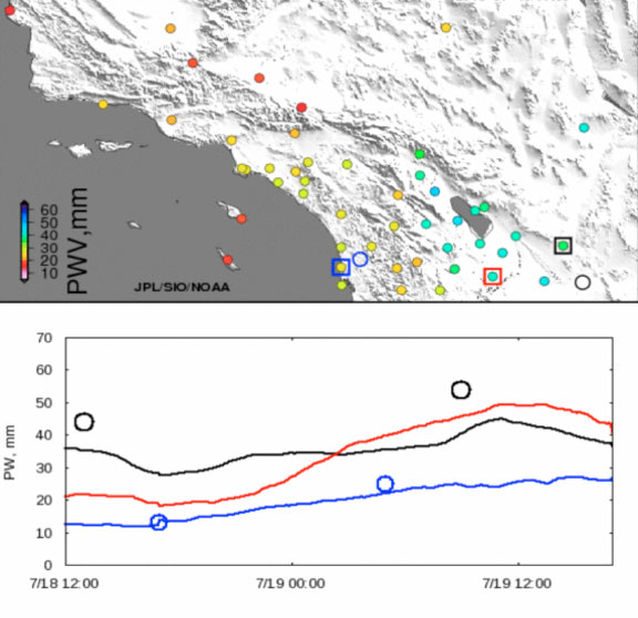
Top: Precipitable water (PW) in mm, indicated according to the color scale, at southern California
GPS stations on 7/19/2014 t 17:00 PDT. Bottom: PW timeseries for stations at San Diego (blue),
El Centro (red), and Yuma (black), indicated with colored squares on the map. Circles indicate locations (at top) and PW values (on bottom graph) from radiosondes.
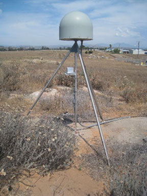
Above: A typical CGPS station in southern California (Image Credit: Y. Bock)
![]()
Bock’s sensor web development began by first enhancing 27 GPS stations in southern California by combining their precise position data with co-located or closely-located meteorological station observations to estimate precipitable water vapor (PWV). The enhanced data were infused into NOAA’s Earth System Research Laboratory’s near real-time analysis of GPS and meteorological data and assimilated in NOAA operational weather models. The addition of the 27 GPS meteorology stations’ data led to approximately a 50 percent reduction in PWV uncertainty. By reducing the uncertainty, forecasters were able to better warn the public of flash flooding during the 2013 North American Monsoon season.
But GPS stations can be used for more than predicting the likelihood of flash flooding. GPS stations sense permanent displacements in the ground, such as the displacements typical of an earthquake. When you add an accelerometer – an instrument that measures the force of that displacement – to GPS data, it is possible to determine both shaking and permanent displacements to rapidly categorize the magnitude of an earthquake in a process called seismogeodesy.
Currently, it is difficult to accurately characterize the magnitude of a major earthquake close to the epicenter (where damage is often greatest) because of magnitude saturation. Accurate seismological data is often collected from seismic stations farther from the epicenter where saturation is less of an issue. It takes time for both the earthquake to propagate away from the epicenter, and for seismologists to collect and analyze the data.
During the 2011 Tohoku-Oki quake, thirty seconds after the earthquake began the magnitude was believed to be 7.2. At 107 seconds the magnitude was raised to an 8. And finally, at 20 minutes after the earthquake first shook, the final magnitude of 9.0 was announced. Magnitude saturation at the seismic stations closest to the epicenter led to the delay in knowing the actual magnitude.
But seismogeodetic stations don’t suffer the same saturation limit that traditional seismic stations encounter in high-magnitude earthquakes and like seismic stations, they very accurately measure P-waves, the first compression waves in an earthquake that arrive before the slower S-waves and surface waves that cause the more-damaging shaking motion.
If seismologists are able to measure the strength of a P-wave moments after it reaches a seismogeodetic station, they can more accurately predict the arrival and strength of the S-wave. This could allow seismologists to warn of a damaging quake just a few seconds or up to two minutes before the damaging quake hits. Time enough to perhaps stop elevators, instruct people to drop, cover and hold on, or keep traffic off of bridges.
To fully understand the impact seismogeodesy could have in enabling early warnings, Bock catalogued seismogeodetic data collected from earthquakes located in California and Japan from 2003 through 2012, a sample-set that includes the 2011 Tohoku-Oki earthquake. Once the data were collected, the project team was able to simulate (data-wise) real-time earthquakes to test that this type of data could assist in more accurate and timely categorizing earthquake magnitude to assist in early warning and tsunami prediction.
In results published in the journal Geophysics Research Letters, Bock’s team’s was able to use seismogeodetic analysis to estimate the final magnitude of the Tohoku-Oki earthquake 150 seconds – just two and a half minutes – after the earthquake origin time. The analysis also produced an accurate fault slip model of the earthquake. That model was then used to estimate uplift of the seafloor. As described in the Journal of Geophysical Research by Bock and graduate student Diego Melgar, the near-coast uplift estimation was able to predict the geographic extent and inundation of the tsunami within three to four minutes of the earthquake origin time. This is vital because in the actual 2011 earthquake, the tsunami’s first waves hit approximately 30 minutes after the earthquake started. The time difference between tsunami prediction and the actual tsunami in this case study would have been great enough to allow life-saving mitigation activities to begin.
With historic data compiled and real-time simulations completed, Bock’s GPS sensor web concept has evidence to support that this method can be useful in earthquake and tsunami early warnings and response. The southern California GPS stations equipped with accelerometers that the project team has developed will be infused into the San Diego County’s office of Emergency Service earthquake and tsunami early warning system as well as the California Department of Transportation’s (Caltrans) bridge monitoring program. The meteorological data the stations collect will also continue to be used by NOAA for forecasting rain and flash flooding events. The geodetic sensor web for natural hazards research and applications may be an important tool in storm, earthquake, and tsunami warning, mitigation and response, and for monitoring large engineered structures such as hospitals and tall buildings.