First flights for AirSWOT
Airborne Instrument to Study Earth’s Water Makes First Flights
Andrea Martin, August 2013
![]()
It is no secret that water is essential for human life. Oceanographers and hydrologists make it their life’s work to understand the dynamic hydrosphere. But still little is known about how much freshwater is available on Earth or how ocean circulation can affect climate change and weather patterns.
To answer these and other questions related to Earth’s water, the decadal survey has called for a new Earth observing mission, Surface Water Ocean Topography (SWOT). This satellite mission, anticipated to launch during 2020, will observe ocean topography and collect data on how bodies of water – lakes, rivers, and reservoirs – change over time. SWOT data will help researchers to estimate fresh water storage and ocean circulation. The ocean is capable of transporting heat and carbon from the surface to the depths of the sea. By collecting data pertaining to circulation, researchers should gain a better understanding of the ocean’s role in a changing climate.
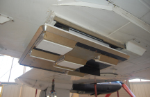
Above: the AirSWOT antenna subsystem mounted underneath the NASA King Air B200 aircraft. (Credit: E. Rodriguez)
Developing a spaceborne instrument capable of the groundbreaking data collection expected of the SWOT mission is cost and risk intensive. But by developing an airborne version of the same instrument, the costs and risks are greatly reduced.
Through ESTO and Small Business Innovation Research (SBIR) funding, an airborne instrument – AirSWOT – was developed to advance the technology needed for SWOT as well as to act as a calibration tool and validation instrument for SWOT data.
The AirSWOT project team, led by PI Ernesto Rodriguez of NASA’s Jet Propulsion Laboratory and Delwyn Moller of Remote Sensing Solutions, has developed an airborne instrument suite comprised of a Ka-band SWOT Phenomenology Airborne Radar (KaSPAR), a multi-purpose Ka-band radar that can obtain cm level topography data of water’s surface and the its changes over time. This radar is combined with a digital camera system to help validate water coverage and to characterize different types of terrain, and a component, the Precision IMU (Inertial Measurement Unit), that can precisely measure altitude and position. Prior to KaSPAR’s development, there was not a sensor that could meet SWOT’s requirements.
AirSWOT made its initial engineering flight in early March onboard NASA’s King Air B200 over Santa Barbara, California. Following the successful first flight, science flights for took place over California’s Sacramento River and Delta the week of May 20th. The data collected, which could be used to for flood modeling and research into tidal effects on the river basin, were calibrated by USGS water-level sensors and by researchers monitoring the flow by boat. The final engineering flights of AirSWOT were completed the week of May 27th, 2013, again over Santa Barbara.
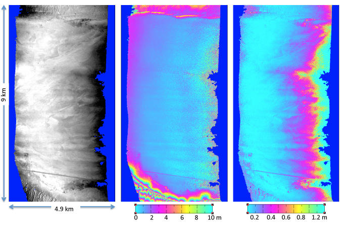
Below: AirSWOT first flight map products of a 9 km by 5 km portion of the Rosamond Dry Lake Bed, CA.
The right image shows the magnitude of the signal return, the middle image is the elevation interferogram,
and the left image provides the elevation error. (Credit: E. Rodriguez)
The AirSWOT science measurements should mark the first time ocean sea surface height measurements at wavelength scales between 10 and 100 kilometers have been collected. In addition the AirSWOT data can demonstrate the ability to estimate river discharge and bathymetry, plus the ability to estimate changes in water storage using SWOT-like measurements.
The data AirSWOT acquires will be used to aid in the engineering of SWOT’s instrumentation and to fine-tune the science measurements of the mission. The AirSWOT team will develop algorithms to process SWOT data that will be used to help determine the Ka-band backscatter characteristics of both water and land. AirSWOT and the corresponding algorithms can also be used study how vegetation may affect the SWOT measurements.
Because AirSWOT will be collecting data years before SWOT is launched, the research and applications community will already be familiar with working with this type of data and will be more readily able to incorporate SWOT measurements into their research and applications. These SWOT-like data products, when used by the scientific community, will demonstrate the algorithms needed to generate level three data.
AirSWOT’s first engineering test flights were an achievement in advancing the technology necessary to collect new science measurements from space. The data collected by AirSWOT can help answer questions on freshwater storage, ocean circulation and even climate change. In future flights, while collecting data for the science community, this airborne instrument’s data can also help to refine the engineering of the spaceborne instrument, thus enabling new measurements while reducing and the risk the cost of SWOT mission development.