Drought in California
Soil Moisture Sensor Web Provides a Peek at California Drought
– Philip Larkin, February 2014
![]()
Water is increasingly in short supply in many parts of the United States. California is particularly dry –2013 was the driest year on record and much of the state is experiencing an extended drought with little or no relief in sight. While rainfall measurements are relatively straightforward, many questions remain about how moisture is stored and distributed in Earth’s soils, how ecosystems function in variable conditions, and how the water cycle is globally regulated. Answering these questions may help us monitor and forecast future droughts, formulate effective water policies, and improve climate change predictions.
Scheduled to launch in late 2014, NASA’s Soil Moisture Active and Passive (SMAP) mission will map Earth’s soil moisture from space and provide some of these answers. In advance of SMAP, an ESTO-funded technology project called SoilSCAPE is installing and testing ground networks of in-situ soil moisture sensors at several test sites. These are smart wireless networks of sensors – sensor webs – that are designed to communicate with each other to adaptively and efficiently measure soil moisture at various depths. The data from the SoilSCAPE test sites will be used to validate SMAP soil moisture products, ensuring the satellite gives accurate readings.
One of the SoilSCAPE sites – Tonzi Ranch near Jackson, CA – is located in the lower foothills of the Sierra Nevada Mountains near the heart of the California drought. SoilSCAPE currently has five other networks nearby in central CA. SoilSCAPE’s principal investigator Mahta Moghaddam and her team at the University of Southern California (MIT, University of Michigan, and ORNL DAAC also participate in the project) have compiled soil moisture data from the Tonzi Ranch network that provides a unique look at the current drought from above and below the surface:
Surface Soil Moisture (5cm), Tonzi Ranch
Left map shows sensor locations, middle map shows interpolated daily average soil moisture data from winter 2012/13,
and right map shows interpolated daily average soil moisture data from winter 2013/14.
Movie credits: Dan Clewley, Agnelo Silva, Ruzbeh Akbar, Mahta Moghaddam
Root Zone Soil Moisture (~40cm), Tonzi Ranch
Left map shows sensor locations, middle map shows interpolated daily average soil moisture data from winter 2012/13,
and right map shows interpolated daily average soil moisture data from winter 2013/14.
Movie credits: Dan Clewley, Agnelo Silva, Ruzbeh Akbar, Mahta Moghaddam
The Tonzi Ranch, CA, SoilSCAPE site:
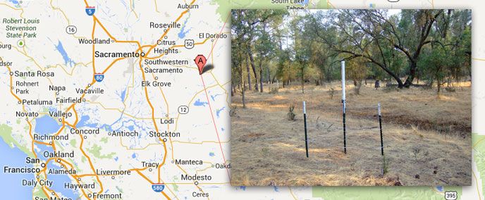
Image Credits: Google Maps and Mahta Moghaddam
—
For more information on the SoilSCAPE, visit the project website at http://soilscape.usc.edu
For more information on emerging technologies for Earth science, visit the NASA Earth Science Technology Office website.