Airborne Multiangle SpectroPolarimetric Imager (AirMSPI)
Airborne Instrument Collects Aerosol Data While Aiding New NASA System
Andrea Martin, November 2012
![]()
To more fully understand the distribution and transport of aerosols as well as their impact on cloud formation and precipitation – all of which can have major effects on Earth’s climate – the National Academy of Sciences Decadal Survey has recommended the Aerosol Cloud Ecosystem (ACE) mission. As part of the mission, different types of aerosols will be measured by ACE’s required multi-angle, multispectral, high accuracy polarization imager. NASA’s Jet Propulsion Laboratory (JPL) is developing the Multiangle SpectroPolarimetric Imager (MSPI) as a candidate for the ACE payload.
The MSPI concept is a follow-on to JPL’s Multi-angle Imaging SpectroRadiometer (MISR) instrument, currently flying on NASA’s Terra satellite. MSPI’s multi-camera architecture will be similar to MISR’s but will extend the imagery from the visible and near-infrared (VNIR) to the ultraviolet (UV) and shortwave infrared (SWIR) spectral regions, and also includes polarization measurements, which will allow for much greater sensitivity to aerosol particle size and refractive index. In addition, MSPI will have a wider field of view than MISR, which will enable more rapid global data collection.
To reduce the risk and cost of developing a space-based instrument, ESTO and NASA’s Research and Analysis Program have funded David J. Diner of JPL and researchers from JPL, the University of Arizona, and the University of Texas to develop AirMSPI – an airborne UV/VNIR prototype instrument that first flew on NASA’s high-altitude ER-2 aircraft in October 2010.
Recently, AirMSPI flew in conjunction with checkout flights for NASA’s Enhanced MODIS Airborne Simulator. During these August 2012 flights, AirMSPI successfully acquired science measurements of cumulus clouds over land, a marine stratocumulus deck and, notably, smoke from an active wildfire.
On August 30th, as AirMSPI flew over the Chips wildfire in northern California, the instrument gathered multi-angle, multispectral data in its eight UV/VNIR spectral bands. Three of these bands provide polarimetric information.
In addition to collecting valuable science data of different cloud types and smoke plumes, AirMSPI participated in tests of NASA’s Airborne Science Data Acquisition and Transmission (NASDAT) unit. First developed for NASA’s Global Hawk data system, NASDAT is now being adapted for use on the ER-2. Using Iridium satellite downlinks, this test allowed real-time monitoring of the AirMSPI instrument status for the first time.
Through an additional ESTO Instrument Incubator Program project, AirMSPI is continuing to be used as a technology testbed for achieving high quality polarimetric imagery. Moreover, the team is developing a second generation instrument, AirMSPI-2, which extends the spectral range into the SWIR. By funding and developing airborne prototypes such as AirMSPI and AirMSPI-2, ESTO is helping NASA ensure that Decadal Survey mission requirements will be met.
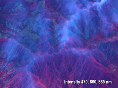
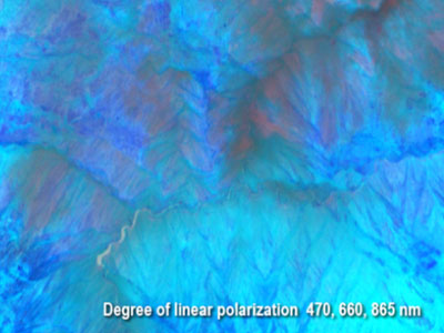
Above: AirMSPI images acquired at a view angle of 60° on 30 August 2012 as the ER-2 overflew the Chips wildfire in Northern California. The top image is a color composite of intensity at 470, 660, and 865 nm, and the image on the bottom is degree of linear polarization (DOLP) in the same bands. Vegetation appears red in the intensity image due to the high reflectance of leaves in the near-infrared; the smoke appears above image center as a bluish haze. The smoke is also visible in the polarization image, with a higher degree of polarization in the near-infrared compared with the other bands, making it appear reddish.