A New Algorithm Aims to Help Better Predict Wildland Fires
10/08/2020 Wildland fires’ towering orange and yellow flames consume trees and vegetation. They can benefit the environment by reducing the grass, brush, and trees that would fuel larger, even more intense fires while also improving wildlife habitat. On the flip slide, when the fires are in the wrong place at the wrong time, they can create devastation for nearby communities and cultural resources.
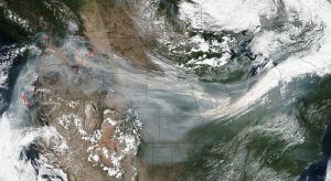
NASA’s Suomi NPP satellite collected this natural-color image using the VIIRS (Visible Infrared Imaging Radiometer Suite) instrument on September 04, 2017. Actively burning areas are outlined in red. NASA image courtesy Jeff Schmaltz LANCE/EOSDIS MODIS Rapid Response Team, GSFC
To better predict how wildland fires will spread, a team of researchers created a machine learning algorithm that predicts fuel moisture content, or the likeliness of vegetation to burn, based on satellite observations.
“One thing that’s really exciting is being able to make the connection between remote sensing and machine learning,” Branko Kosovic, the Director of the Weather Systems and Assessment Program at the National Center for Atmospheric Research in Boulder, Colorado and the project’s lead investigator, said. Combining the two tools allows decision makers to get better coverage of the fires across the United States.
The project was funded by NASA’s Advanced Information System Technology program. Kosovic and colleagues recently published their findings in the journal, Machine Learning: Science and Technology, published by IOPScience.
Elizabeth Goldbaum
Elizabeth.F.Goldbaum@nasa.gov